Thursday, January 04, 2007
Hiking with GPS at Cache Creek, Jan 3, 2007
GPS may be a useful tool for whitewater river trips
JimH & I went up to Cache Creek with his waterproof GPS unit to explore how useful GPS may be for documenting river trips. We were able to get GPS data at many points along the Rumsey Run, including a fairly steep and deep part of the canyon just below Mother Rapid. The unit needs to achieve simultaneous line-of-sight with a number of satellites to achieve an accurate position. This may be a problem in some deeper, steeper canyons with more tree cover, but it seems likely that this will be useful on many rivers and creeks.
Another issue is matching up the many photographs taken during a river trip with the exact locations in the canyon where the photos were taken. We were able to photograph the GPS unit display to insert the GPS location data into a picture collection. GPS waypoints could be taken at various landmarks along the river (i.e. major rapids, sidecreek hikes, etc.). Then photographers in the group could snap pictures of the GPS display to insert the data for the landmarks into their series of pictures.
Inspecting the riverbed
With the creek flowing at 25 cfs it was interesting to see the riverbed underneath some of the rapids with which we are familiar. Normally we are running them at higher flows where the rocks are mostly covered by whitewater. HEY, enough of that!!! Lets get some rain so the new kayaking season can begin!!!
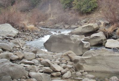
---------picture at Widowmaker Rapid

---------picture at Mother Rapid (photo by JimH)
Finding a Geocache
Geocaching adds an element of hide-and-seek for the GPS-enabled traveler. On the way home JimH located a geocache along Hwy 16 at the site of an abandoned historical rural school building.
Road map, gas, food & lodging: Rumsey, CA - MapQuest.
Local weather: Rumsey, CA - weather.com
More about:
• Trip Reports - Whitewater River Kayaking.
• Hiking & Camping Trip Reports - BRT Insights.
• California Hiking Trails - Statewide Information.
• California Maps - Atlas & Gazetteer by Delorme, 2008.
Tags: kayaking, GPS, geocache, whitewater, rivers.
![]()


