Saturday, January 27, 2007
Northern California Atlas & Gazetteer 6th edition (book review)
Topographic Maps - Kayakers, canoers and rafters need good maps for GPS, trip planning and driving directions.
| Published by DeLorme, 6th Edition, 2003. ISBN-10: 0899332870. ISBN-13: 978-0899332871. The book Northern California Atlas & Gazetteer |
This DeLorme Gazeteer is a very valuable resource for boating (kayaking, canoeing & rafting) in California, both for trip planning and for driving to your destination. Don't leave home without it !! (**** - my rating 4 stars out of 5).
More about: Reviews - Books, Videos, & Websites.
Tags: kayaking, whitewater, rivers, rafting, canoeing, gps, topographic.
Friday, January 26, 2007
Wiki Websites for Kayakers, Canoers & Rafters (website reviews)
Whitewater wikis are written and edited by their communities of users.
They are part of the new web 2.0 movement towards more community participation on the Internet. Whitewater boaters can register for free and then easily learn how to publish on a wiki. Wikis can provide opportunities for the occasional whitewater writer and for writers who want to contribute to the team effort of building a big, valuable and informative wiki boating site. You can edit what somebody else has written on the wiki, but others can also re-edit what you have done.More whitewater boaters are needed to add their knowledge to these wikis.
Sign up and contribute!! Wikis could grow to become very valuable resources if enough kayakers, rafters and canoers would contribute information and help keep the whitewater wikis more up-to-date than any published boating guidebook could ever be. (Updated 11dec2007.)Wikipaddle. Wikipaddle has 316 paddling guides for kayaking, rafting and canoeing paddlesports around the globe, just a tiny sample of the available places to paddle. It contains sections on places, equipment, technical and books. It has very nice interactive Google maps, and longitude and latitude information for many landmarks. (** - my rating 2 stars out of 5).
Whitewater Rivers of Chile and Argentina - Expediciones Chile. Excellent paddlesports guide to some of the whitewater rivers with Google maps, links and detailed descriptions of the river runs, but still incomplete. (** - my rating 2 stars out of 5).
Water Trail Wikis. San Francisco Bay Area Launch Sites, California Put-ins, Columbia River Water Trail. Class I river and coastal boating location guides. Nice descriptions including Google maps. Good flatwater touring site, but little or no whitewater. (* - my rating 1 star out of 5).
List of whitewater rivers - Wikipedia. A big resource of historical and economic development information, but still very incomplete. Very little information about recreation, geology, wildlife, geography, or conservation. Very few and very poor static maps. (* - my rating 1 star out of 5).
KayakWiki. (My rating 0 stars).
Kayak - Wikimedia Commons. (My rating 0 stars).
Playak Wiki. (My rating 0 stars).
WikiOutdoors. (My rating 0 stars).
World Kayak River Wiki. (My rating 0 stars).
More about: Reviews - Books, Videos, & Websites on Paddlesports.
Tags: wiki, web 2.0, whitewater, rivers, paddlesport, kayaking, rafting, canoeing.
Sunday, January 21, 2007
Folsom Dam Project Needed for Sacramento Flood Control
Please send your comments before Fri Jan 26, 2007 !!
Modifications of Folsom Dam (Sacramento County, California, USA) are needed to increase protection against flooding in Sacramento. Sacramento currently has the least protection against flooding of any major city in the US. This upgrading of our current flood control structures is cost-effective for taxpayers. It also protects the environment by reducing the need for new water development projects (i.e. additional dams or other new flood control structures) on pristine sections of river.Time for comment on Folsom Dam project - sacbee.com 21jan2007. "Comments on the draft environmental study may be submitted to Shawn Oliver, Bureau of Reclamation, 7794 Folsom Dam Road, Folsom, CA 93630, or soliver@mp.usbr.gov. Comments also may be sent to Becky Victorine, U.S. Army Corps of Engineers, Sacramento District, 1325 J St., Sacramento, CA 95814, or Rebecca.A.Victorine@usace.army.mil."
For more information see:
* Folsom Dam Safety and Flood Damage Reduction EIS/EIR - usbr.gov
* SAFCA Newsletter Oct 2006 (pdf) "Taking Sacramento to 200-year protection." "Modify Folsom Dam." "Continue to strengthen, armor and raise the levee system."
* Flood Protection Plan for Sacramento is on Track.
More about: River Conservation and Flood Control.
Tags: river conservation, environment , conservation, rivers, flood, flooding, dam, levee, water development.
Labels: conservation
Tuesday, January 16, 2007
Midwest Paddle Adventures uses GPS to document river trips
Midwest Paddle Adventures blog is a leader in use of GPS to document kayak boating trips.
In recent posts he describes Creating Free GPX Files from Google Earth and more detailed instructions. Its still kind of a mystery to me, but I'm excited to learn more about it. Clearly this will make topographic maps even more useful for planning of whitewater kayaking, canoeing, rafting, hiking, biking and other outdoor adventure trips!More about: Trip Reports - Whitewater River Kayaking.
Tags: kayaking, whitewater, rivers, rafting,
canoeing, gps, topographic.
Labels: map
Monday, January 15, 2007
Water Development Plans for California
River conservation vs. water development issues will likely be big news in California this year.
Under a cryptic headline Dan Walters described some potential water development projects for California that may be in the news in 2007. Watch out for proposals to build dams to create two new reservoirs. Plans are also being revived to build the peripheral canal which would convey water around the Sacramento-San Joaquin Delta.More about: River Conservation and Flood Control.
Tags: river conservation, conservation, rivers, dam, water development.
Labels: conservation
Saturday, January 06, 2007
Road Maps Online
Trip planning resource for boating, hiking, biking, & camping.
These websites provide maps, driving directions, and information about local businesses (gas, food, lodging, etc.). Good coverage of highways, major rivers, cities and towns. Variable coverage of county roads, lesser rivers, creeks and rural areas. If you are not going too far from urban areas, then these maps are pretty good. If your destination is out in the backcountry, possibly boating on a small river or creek, then these maps will definitely need to be supplemented with topo maps for planning of your trip. Nevertheless, these sites are good resources for travelers.Mapquest | Yahoo Maps | Google Maps | MSN Virtual Earth | SuperPages | Switchboard.
(*** rated - 3 stars out of 5)
Too many of the lesser rivers and larger creeks are missing for a kayaker like me to rate these map sites very highly. In the few areas where I've checked the maps on these sites are similar, maybe identical. If one is any better than another it would have to be based upon minor details of the interface or on coverage of local businesses.
More about: Reviews - Books, Videos, & Websites.
Labels: map
Friday, January 05, 2007
Topographic Maps Online
River trip planning and documentation resources
Topographic maps have long been invaluable for wilderness exploration. Now that these online maps provide longitude and latitude coordinates they become even more valuable for the GPS-enabled traveller. I think that GPS mapping will become the standard way to mark positions of whitewater rapids, put-ins, take-outs, shuttle roads, hiking trails and other outstanding features of our river canyons.
ACME Mapper 2.0.
Provides road map, satellite map, hybrid, topo, DOQ, & NEXRAD. Hover over a point to get its coordinates. Enter coordinates and go to that point !!!! (***** 5 stars - highly recommended!)
Maptech MapServer.
This interface enables both jumping to the coordinates that you enter and learning the coordinates of any point on the map. (***** 5 stars - highly recommended!)
TopoZone.
Click on the map to get the coordinates for that point, but this interface does not provide the ability to enter coordinates and jump to that point on the map. Provides many display options for coordinate formats (UTM, DD.DDD, D/M/S, DD MM.MM) and map datum (NAD27, NAD83/WGS84). (**** 4 stars)
TerraServer-USA.
Find locations on the maps by name or by coordinates, but this interface does not provide the ability to click on the map and learn the coordinates of that point. (*** 3 stars)
More about: Reviews - Books Etc.
Labels: map
Thursday, January 04, 2007
Hiking with GPS at Cache Creek, Jan 3, 2007
GPS may be a useful tool for whitewater river trips
JimH & I went up to Cache Creek with his waterproof GPS unit to explore how useful GPS may be for documenting river trips. We were able to get GPS data at many points along the Rumsey Run, including a fairly steep and deep part of the canyon just below Mother Rapid. The unit needs to achieve simultaneous line-of-sight with a number of satellites to achieve an accurate position. This may be a problem in some deeper, steeper canyons with more tree cover, but it seems likely that this will be useful on many rivers and creeks.
Another issue is matching up the many photographs taken during a river trip with the exact locations in the canyon where the photos were taken. We were able to photograph the GPS unit display to insert the GPS location data into a picture collection. GPS waypoints could be taken at various landmarks along the river (i.e. major rapids, sidecreek hikes, etc.). Then photographers in the group could snap pictures of the GPS display to insert the data for the landmarks into their series of pictures.
Inspecting the riverbed
With the creek flowing at 25 cfs it was interesting to see the riverbed underneath some of the rapids with which we are familiar. Normally we are running them at higher flows where the rocks are mostly covered by whitewater. HEY, enough of that!!! Lets get some rain so the new kayaking season can begin!!!
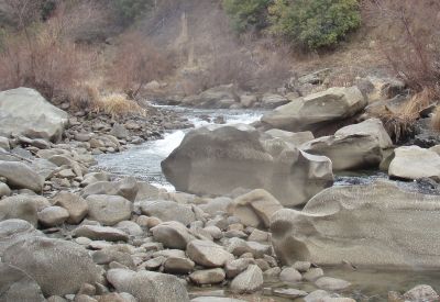
---------picture at Widowmaker Rapid

---------picture at Mother Rapid (photo by JimH)
Finding a Geocache
Geocaching adds an element of hide-and-seek for the GPS-enabled traveler. On the way home JimH located a geocache along Hwy 16 at the site of an abandoned historical rural school building.
Road map, gas, food & lodging: Rumsey, CA - MapQuest.
Local weather: Rumsey, CA - weather.com
More about:
• Trip Reports - Whitewater River Kayaking.
• Hiking & Camping Trip Reports - BRT Insights.
• California Hiking Trails - Statewide Information.
• California Maps - Atlas & Gazetteer by Delorme, 2008.
Tags: kayaking, GPS, geocache, whitewater, rivers.
![]()


