Monday, November 29, 2010
Lower Colorado River Flatwater Paddleboating in Arizona and Nevada - Trip Report Archive 2009 and older.
• Back to Lower Colorado River Guide and Map for Paddleboating (NV, AZ).
Excellent big canyon scenery, year-round flows, hotsprings, hiking and camping make the lower Colorado River Black Canyon a special place. Further proof of its greatness is the number of boaters who are inspired to post online reports from their river trips. (Arizona, Nevada)
A. Black Canyon Colorado River trip reports - archive 2009 and older.
• Kayaking the Black Canyon of the Colorado River - Kim and Geoff 19dec2009.
• Kayaking the Colorado River below Hoover Dam - libertyridgeranch 27oct2009.
• Kayaking Black Canyon on the Colorado River - geobau 04oct2009.
• Bob & Lisa's Kayaking Black Canyon trip report photos oct2009.
• Black Canyon Rafting Adventure video - finleyholiday 24july2009.
• Black Canyon Kayaking video - greenriver2008 07june2009.
• Kayaking Black Canyon photos - Akersons 03may2009.
• Black Canyon kayaking, Valley of Fire, and Hoover Dam - scoaoutdoors 09april2009.
• Valley Of Fire and Black Canyon photos - Stein 10april2009.
• Meetup Black Canyon -Valley of Fire photos - Katja 10april2009.
• Black Canyon Colorado River photos - Captain Kayak 21march2009.
• Black Canyon Colorado River photos - cPaula 18march2009.
• Colorado River kayaking video - EEVB12 09feb2009.
• Kayaking Colorado River photos - kayak.wa 14mar2009.
• Black Canyon kayaking video - sherry 2009.
• Colorado River Black Canyon - Yakpacking 2009.
• Kayaking & Canoeing at Willow Beach video - ajvegass 02sept2008.
• Kayaking the Colorado River: Living Las Vegas 27aug2008.
• Ant Paddling Over the Rapids on the Colorado video - amederos1 23june2008.
• Canoeing Black Canyon Hoover Dam V2 video - johnrweb 10may2008.
• TrailCafe: Black Canyon of the Colorado River april2008.
• Colorado River - Hoover to Davis - twodresslers 04jan2007.
• Aqua Adventures Black Canyon kayaking photos - valker3 20nov2006.
• Black Canyon kayaking photos - adnahr 20nov2006.
• Colorado River Black Canyon kayaking photos - jbkayaker 17sept2006.
• Black Canyon, Lower Colorado River canoeing photos - Stephen Paul may2006.
• Colorado River: Black Canyon - NV - HappyCamperToo 16mar2006.
• Kayaking Black Canyon on the Colorado River - KariB 15jan2006.
• Kayaking Black Canyon trip report & photos - chucksweb.net Feb 2005.
• Black Canyon Lower Colorado River photos - Stephen Paul 03june2002.
• Black Canyon - Lower Colorado River canoeing photos - bajataco 2002.
• Flat Water Rafting on the Colorado River at the base of Hoover Dam - Sandra Scott.
• Lower Colorado River - Black Canyon to Nelson's Landing - soazpaddlers.
• Black Canyon Canoe Trip: Hoover Dam To Willow Beach - Ramkitten.
Back to: Paddle Boating Map and Guide for Lower Colorado River (NV, AZ).
IceRocket Tags: river map, kayaking, rowing, river tubing, float tube, socal, Southern California.
Tags: Colorado River, California, Nevada, Arizona, kayaking, paddlesports, river, rafting, canoeing, paddle boating.
Labels: guide
Saturday, November 27, 2010
Fall Leaf Colors Brighten Up the Landscape in Davis, California USA.
Bringing my camera while hiking and biking around town enabled me to get some nice photos of fall scenery in Yolo County. Its amazing how much better photos are when an interesting subject is photographed with a dramatic sky in the background.
Click on the pictures to see a larger version. Use the back button to return.


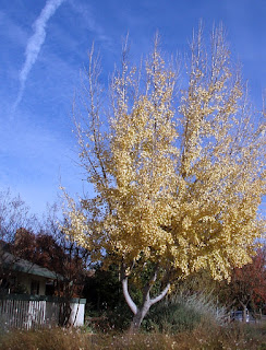
More fall leaf pictures: Fall leaf colors in Davis, CA pictures 25nov2010.
Camera: Olympus Stylus 720SW waterproof camera.
Photo editing: IrfanView software for viewing and editing of digital photographs.
For more information: Fall Leaves - Recreation and Places to Visit - Sacramento Bee.
Click on the pictures to see a larger version. Use the back button to return.


More fall leaf pictures: Fall leaf colors in Davis, CA pictures 25nov2010.
Camera: Olympus Stylus 720SW waterproof camera.
Photo editing: IrfanView software for viewing and editing of digital photographs.
For more information: Fall Leaves - Recreation and Places to Visit - Sacramento Bee.
Labels: hiking
Wednesday, November 24, 2010
Eel River Lower Runs - Wild and Scenic Flatwater Paddleboating in California USA.
River Map & Guide for Canoeing, Kayaking, Rowing, Rafting & Tubing Paddlesports.
The South Fork and Main Eel River provide 122 miles of flatwater class I paddleboating, including many areas of outstanding scenic beauty.Lower Eel River Flatwater Boating Runs - Mendocino County & Humboldt County.
--- Eel River Main Fork. Run name (mileage, whitewater class). ---1. Alderpoint to Dyerville Run (30 miles, class I).
2. Dyerville to Ocean Run (44 miles, class I).
--- Eel River South Fork. Run name (mileage, whitewater class). ---
3. Piercy to Dyerville Run (48 miles, class I).
Real-time Flow - lower Eel River to the Pacific Ocean.
The Lower Eel River flows in the Main Fork and South Fork are determined primarily by rainfall in the winter and spring rainy seasons. Flows can vary dramatically in different segments of the river depending upon which of the side-creek drainages has received the most rain in the past few days. Be sure to use the flow gauge that is closest to the section of river that you plan to paddle.--- Real-time Flow Eel River Main Fork. (See marker on map.) ---
• Eel River at Fort Seward - USGS Real-Time Water Flow Data. (B)
• Eel River at Scotia - USGS Real-Time Water Flow Data. (E)
• Eel River at Fernbridge - USGS Real-Time Water Flow Data. (F)
--- Real-time Flow Eel River South Fork. (See marker on map.) ---
• SF Eel River at Leggett - USGS Real-Time Water Flow Data. (G)
• SF Eel River nr Miranda - USGS Real-Time Water Flow Data. (J)
River Map - access locations for lower Eel River paddle boating.
• Map user FAQ. The map is interactive. Click and drag to reposition map.• Use the tool on the left to zoom in and out. Point on the red markers to see their names.
• Map button = road map. Terrain = 3D shaded topo map. Topo = topographic map.
• Full-Screen River Map: Eel River access locations.
Geographic coordinates - Landmark name (marker on map above)
--- Eel River Main Fork. ---
N 40.17310 W 123.60477 - Alderpoint (A)
N 40.21827 W 123.63261 - Fort Seward (B) river gauge.
N 40.29007 W 123.73180 - Eel Rock (C)
N 40.35472 W 123.92509 - Dyerville (D) confluence of SF and main Eel River.
N 40.49174 W 124.10036 - Scotia (E) river gauge.
N 40.61069 W 124.20336 - Fernbridge (F)
N 40.49102 W 124.10036 - Pacific Ocean
--- Eel River South Fork. ---
N 39.87497 W 123.71979 - Leggett (G) river gauge.
N 39.96745 W 123.80279 - Piercy (H) put-in for class I section.
N 40.09022 W 123.79746 - Garberville Tooby Park (I)
N 40.18179 W 123.77624 - Miranda (J) river gauge.
N 40.35472 W 123.92509 - Dyerville (D) confluence of SF and main Eel River.
Driving Directions, Map, Distance, Estimated Time & Road Conditions.
Mapquest provides directions, distance & time from your house to the river.• From Davis, CA to Alderpoint, CA - driving time 4 hours 31 minutes - 234 miles.
California Road Conditions (Delays or closures due to weather, construction, etc.)
• California Travel Information - highwayconditions.com.
• Road Conditions - California Dept Transportation.
Local weather in Alderpoint, California (elevation 472 feet).

Online River Guides & River Flow Data for Paddle Boating.
• Eel River Paddleboating Directory.(Display options - alphabetical 100. See section 1.)
Printed Guidebooks & Maps - Eel River Flatwater.
• Paddling Northern California by Charlie Pike 2001. (pg. 76-88, SF Leggett to Weott, Main Fork Eel Rock to Whitlow)• Ann Dwyer's Easy Waters of California North, 2000. (pg. 96-110, SF Garberville to Dyerville, Main Fork Alderpoint to Ocean)
• West Coast River Touring - Rogue River Canyon and South, 1974. (pg. 133-158, SF Piercy to Dyerville, Main Fork Alderpoint to Dyerville)
• Down the Wild Rivers- A Guide to the Streams of California, 1972. (pg. 85-104, SF Piercy to Dyerville, Main Fork Alderpoint to Fernbridge)
• California River Maps - Atlas & Gazetteer by Delorme, 2008.
Flatwater River Trip Reports NEEDED !!
Please contact me to send in your Eel River trip report. I'm eager to post or link to boating trip stories from guest authors, especially if boating pictures and/or videos are included.• Eel River Alderpoint to Eel Rock kayak trip pictures - Glen and Lorrie May 2008.
• Back Paddling Eel River in a kayak video - loletaeric 20jan2008.
• Eel River Alderpoint to Eel Rock - postcanoeclub.org 03may2002
Eel River Conservation & Recreation.
• Eel River is protected in the Wild and Scenic River - USA National Program.• Eel River Watershed Directory - Restoration, Conservation & Recreation. Eel River valley websites. (Display options - alphabetical 100. Section 1=kayaking-canoeing, 2=rafting, 3=conservation, 4=fishing, 5=camping-hiking, 6=local-info)
Float Tubing - River Tubing - Innertubing.
• Float Tube (Innertube) Techniques, Skills and Safety for your River Trips.• Equipment for Float Tubing River Trips - BRT Insights.
More about:
• Eel River Guide for Whitewater and Flatwater Paddle Boating.
• North Coast California River Guides for Paddleboating.
• California Flatwater and Whitewater River Guides for Paddleboating.
IceRocket Tags: canoeing, rafting, rowing, river tubing, float tube, flatwater, river map, kayaking.
Tags: Eel River, California, flatwater, river map, river, Wild and Scenic, paddle boating, paddlesports, Mendocino County, Humboldt County, Wild and Scenic Rivers.
Labels: guide
Friday, November 19, 2010
Feather River Lower Run - Flatwater Paddle Boating in California USA.
River Guide & Map for Canoeing, Kayaking, Tubing & Rafting.
From Oroville Reservoir to the Sacramento River confluence at Verona the Feather River provides 64 miles of river with a year-round flow for flatwater class I paddle boating.Boating Runs on lower Feather River - Butte, Sutter & Yuba Counties.
Run name (whitewater class, mileage).1. Oroville Dam to Thompson Flat (class I, 4 miles)
2. Fish Hatchery to Verona (class I, 60 miles)
Real-time Flow - lower Feather River to confluence with Sacramento River.
The Lower Feather River flow at Oroville, CA is determined primarily by the water release from Oroville Dam. The Yuba River adds its flow at Yuba City, CA. The Bear River adds its flow near Rio Oso, CA.• Feather River at Gridley - real-time flow data CDEC.
• Feather River at Boyd's Landing - real-time flow data CDEC.
• Feather River at Boyd's Landing - real-time flow data AHPS.
River Map showing access locations for Feather River paddle boating.
• Map user FAQ. The map is interactive. Click and drag to reposition map.• Use the tool on the left to zoom in and out. Point on the red markers to see their names.
• Map button = road map. Terrain = 3D shaded topo map. Topo = topographic map.
• Full-Screen River Map: Lower Feather River put-in & take-out locations.
Geographic coordinates - Landmark name (red markers on map above)
N 39.53807 W 121.50390 - Oroville Dam (A)
N 39.53317 W 121.54578 - Thompson Flat.
N 39.51709 W 121.55445 - Feather River Fish Hatchery
N 39.51238 W 121.56870 - Bedrock Park (B).
N 39.36645 W 121.64569 - Gridley Bridge & river gauge (C)
N 39.14124 W 121.60681 - Yuba City Riverfront Park (D)
N 39.04540 W 121.60992 - Boyd's Landing & river gauge (E).
N 38.78674 W 121.61985 - Verona confluence with Sacramento River (F)
Many alternate put-in and take-out locations are available to enable flatwater boating trips of various distances.
Driving Directions, Distance, Estimated Time & Road Conditions.
Mapquest provides directions, distance & time from your house to the river.• From Davis, CA to Oroville, CA - driving time 1 hour 26 minutes - 79.72 miles.
California Road Conditions (Delays or closures due to weather, construction, etc.)
• California Travel Information - highwayconditions.com.
• Road Conditions - California Dept Transportation.
Local weather in Oroville, California (elevation 174 feet).

Online Boating Information - lower Feather River.
• Feather River Lower Runs Paddleboating. (Set display options - alphabetical 100. See sections 1 & 2.)Paddleboating Guidebooks - lower Feather River.
• Paddling Northern California by Charlie Pike. (pg. 124-128, Oroville to Wildlife Refuge)• Ann Dwyer's Easy Waters of California North, 2000. (pg. 180-183, Oroville to Verona)
• Down the Wild Rivers- A Guide to the Streams of California, 1972. (pg.153-155, Oroville to Verona)
Feather River Trip Reports NEEDED !!
Contact me to submit your flatwater paddleboating trip report from the Lower Feather River. I'm happy to post or link to well-written, whitewater boating trip reports from guest authors, especially if boating pictures and/or videos are included.• Feather River kayaking - sskpc 16sept2008. Oroville Dam to Verona.
• Feather River kayaking Oroville to Gridley video - featherriverrafter 29may2008. Oroville Fish Hatchery to Gridley.
• Feather River Kayaking from Oroville to Gridley - mysticalessence. Bedrock Park to Gridley.
• Feather River - pfflyer. Oroville Dam to Thompson Flat.
Feather River Conservation & Recreation.
• Feather River Lower - Conservation & Recreation Directory. (Section 1=kayaking, 2=rafting, 3=conservation, 4=fishing, 5=camping-hiking, 6=local-info) Feather River valley outdoor activities websites.Float Tubing - River Tubing - Innertubing.
• Float Tube (Innertube) Techniques, Skills and Safety for your River Trips.• Equipment for Float Tubing River Trips - BRT Insights.
More information:
• Feather River Paddle Boating Guide Overview. Includes whitewater upstream and flatwater downstream.
• Whitewater & Flatwater River Guides for canoeing, kayaking, tubing & rafting in California.
• California River Maps &a Road Maps - Atlas & Gazetteer by Delorme, 2008.
IceRocket Tags: flatwater, river map, kayaking, canoeing, rafting, river tubing, float tube.
Tags: paddle boating, river, valley, Feather River, Butte County, Sutter County, Yuba County, California.
Labels: guide
Wednesday, November 17, 2010
Sacramento River - Red Bluff to San Francisco Bay - Whitewater Paddleboating in California USA.
River Guide & Map for Kayaking, Tubing, Canoeing & Rafting.
From Red Bluff to San Francisco Bay the Sacramento River provides 150 miles of river with a year-round flow for class I paddle boating.Whitewater Runs on lower Sacramento River - Tehama, Glenn, Colusa, Sutter, Yolo, Sacramento & Solano Counties.
Run name (whitewater class, mileage).1. Red Bluff Diversion Dam to Knight's Landing (class I, 72 miles)
2. Knight's Landing to San Francisco Bay (class I, ~75 miles)
Many alternate put-ins and take-outs are available to make trips of various lengths.
Real-time Flow - lower Sacramento River to California Delta & SF Bay.
The Sacramento River flow at Colusa, CA is determined primarily by the water release from Keswick Dam. Various tributaries may add to the flow and various water diversions reduce the flow that remains in various sections of the river.USGS Real-Time Flow Data for Sacramento River at Colusa CA.
Different river flow gauges should be used for downstream sections of the Sacramento River:
• USGS Real-Time Flow Data for Sacramento River at Verona CA. Below Feather River confluence.
• USGS Real-Time Flow Data for Sacramento River at Freeport CA. Below American River confluence.
River Map showing put-in locations for Sacramento River paddleboating.
• Map user FAQ. The map is interactive. Click and drag to reposition map.• Use the tool on the left to zoom in and out. Point on the red markers to see their names.
• Map button = road map. Terrain = 3D shaded topo map. Topo = topographic map.
• Full-Screen River Map: Sacramento River Red Bluff to SF Bay put-in & take-out locations.
Geographic coordinates - Landmark name (marker on map above)
N 40.17848 W 122.23148 - Red Bluff Diversion Dam (A)
N 40.02893 W 122.11784 - Driftwood Resort (B)
N 39.90974 W 122.09141 - Woodson Bridge SRA (C)
N 39.75049 W 121.99768 - Irvine Finch River Access (D)
N 39.73782 W 121.95923 - Scotty's Boat Landing (E)
N 39.21593 W 122.00970 - Colusa Levee Scenic Park, river gauge (F)
N 38.80213 W 121.71907 - Knight's Landing (G)
N 38.59943 W 121.50879 - Discovery Park (H)
N 38.16075 W 121.68594 - Rio Vista (I)
N 38.07553 W 121.84988 - Collinsville (J)
Many alternate put-in and take-out locations are available to enable boating trips of various distances.
Driving Directions, Distance, Estimated Time & Road Conditions.
Mapquest provides directions, distance & time from your house to the river.• From Davis, CA to Red Bluff, CA - driving time 1 hour 56 minutes - 126 miles.
California Road Conditions (Delays or closures due to weather, construction, etc.)
• California Travel Information - highwayconditions.com.
• Road Conditions - California Dept Transportation.
Local weather in Colusa, California (elevation 59 feet).

Online Boating Information - lower Sacramento River.
• Sacramento River Lower Runs Paddleboating. (Set display options - alphabetical 100. See sections 1 & 2.)Whitewater Guidebooks - lower Sacramento River.
• Paddling Northern California by Charlie Pike. (pg. 105-123, Redding to Colusa)• Ann Dwyer's Easy Waters of California North, 2000. (pg. 164-175, Redding to Sacramento)
• Down the Wild Rivers- A Guide to the Streams of California, 1972. (pg.156-166, Redding to Knight's Landing)
Whitewater River Trip Reports NEEDED !!
Contact me to submit your paddleboating trip report from the Lower Sacramento River. I'm happy to post or link to well-written, whitewater boating trip reports from guest authors, especially if boating pictures and/or videos are included.• Labor Day Float Preparations - Chico Enterprise-Record 04sept2010.
• Canoe Camping on the Sacramento River - Triporati 05aug2010.
• Cata raft Maiden Voyage from Woodson to Scotty's video - 15sept2009.
• Sacramento River Labor Day Float at Chico - CampusGrotto 03sept2008
• Sacramento River Rafting video - jrizalstreet 19aug2008.
• Sacramento River Red Bluff to Los Molinos - paddling.net 01jan2007.
• Labor Day Live on the Sacramento River - norcalblogs 05sept2006
• Annual Club Picnic and Sacramento River Kayak/Canoe pictures - weskiii 22aug2005.
• Sacramento River from Irving Finch access to Ord Bend pictures - wildenhaus100 june2004.
• Sacramento River from Woodson Bridge to Irving Finch pictures - wildenhaus100 21aug2004.
• Tubing down the Sacramento River picture - richardcclark 1983.
Whitewater River Conservation & Recreation.
• Sacramento River Lower - Conservation & Recreation Directory. (Section 1=whitewater, 2=rafting, 3=conservation, 4=fishing, 5=camping-hiking, 6=local-info) Sacramento River valley websites.River Tubing - Float Tubing - Innertubing.
• Float Tube (Innertube) Techniques, Skills and Safety for your River Trips.• Equipment for Float Tubing River Trips - BRT Insights.
More about:
• Sacramento River Paddle Boating Guide Overview.
• Whitewater River Guides for canoeing, kayaking, tubing & rafting in California.
• California River Maps & Road Maps - Atlas & Gazetteer by Delorme, 2008.
IceRocket Tags: whitewater, river map, kayaking, canoeing, rafting, river tubing, float tube.
Tags: paddle boating, river, valley, Sacramento River, Tehama County, Glenn County, Colusa County, Sutter County, Yolo County, Sacramento County, Solano County, California.
Labels: guide
Friday, November 12, 2010
Repairing Your Polyethylene Kayak or Canoe by Welding or Patching.
Repair linear polyethylene boats by plastic welding.
Kayak Magazine had an article recently about plastic welding to repair cracks and holes in high density polyethylene (HDPE) boats. Repair Hole in Polyethylene Kayaks 03sept2010. You can purchase a plastic welding tool from Harbor Freight Tools for $15 to $75. Detailed instructions for plastic welding are provided by Ocean Kayak.Patch crosslinked polyethylene boats with duct tape.
Surprisingly durable patches for crosslinked polyethylene boats can be made by carefully heating a patch made with duct tape. Repair cracked kayaks with duct tape and a hair dryer.More about:
• Whitewater River Kayaking, Canoeing & Paddleboating Equipment Reviews - BRT Insights.
• River Kayaking, Canoeing, Rafting & Tubing News Websites - BRT Insights.
Tags: kayaking, canoeing, polyethylene, whitewater, rivers, paddleboating.
Labels: equipment
Wednesday, November 10, 2010
Ode to the Club Boater - whitewater river kayaking carnage video by tgerencer1.
I haven't been a big fan of whitewater river boating carnage videos, but this one has a great combination of video, music, lyrics and humor.
Ode to the Club Boater video by tgerencer1 22oct2010. Please make good or bad comments about the humor at YouTube where the video was originally posted.
Once the survival of the victim is assured I'm most interested to use carnage videos or photos as a learning experience for whitewater river boating safety skills. Should the boater have scouted, or portaged or run a different line through the rapid? Did the boater do the right things for self-rescue? Did the boating group do the right things to ensure a safe and efficient assisted rescue if necessary?
Please add comments to let us know your favorite whitewater boating carnage videos and the lessons, if any, that you learned from them.
More about:
• Critical reviews of books and videos for whitewater river kayaking - BRT Insights.
• Skills & Techniques for Whitewater River Kayaking & Freestyle Playboating.
IceRocket Tags: carnage video, whitewater video, boating safety.
Tags: kayaking, whitewater, river, paddle boating, paddlesport.
Labels: video
Friday, November 05, 2010
Sacramento River - Redding to Red Bluff - Whitewater Paddleboating in California USA.
River Kayaking, Canoeing, Tubing & Rafting Guide - Shasta County & Tehama County.
Paddle Boating on the lower Sacramento River.
Below Lake Shasta the Sacramento River from Redding to Red Bluff provides 56 miles of "big water" class I-II boating with year-round flows. Many areas of the river outside of the urban areas have very good scenery and wildlife viewing opportunities.Run name (whitewater class, mileage)(coordinates of access points).
1. Keswick Dam to Ball's Ferry (class I-II, 22 miles) (N 40.60998 W 122.44597)
2. Ball's Ferry to Red Bluff (class I-II, 34 miles) (N 40.41716 W 122.19337)
Real-time Flow Data - Sacramento River.
This river run is fed by the water release from Keswick Dam.Flow site: USGS 11370500 real-time flow - release from Keswick Dam.
River Map showing put-in locations for Sacramento River paddleboating.
• The map is interactive. Click and drag to reposition map. Map user FAQ.• Point on the red markers to see their names. Use the tool on the left to zoom in and out.
• Map button = road map. Terrain = 3D shaded topo map. Topo = topographic map.
• Full-Screen River Map: Sacramento River Redding to Red Bluff put-in & take-out locations.
Geographic coordinates - Landmark name (marker on map)
N 40.60998 W 122.44598 - Keswick Dam (A).
N 40.59140 W 122.37328 - Turtle Bay Bird Sanctuary (B).
N 40.47212 W 122.26882 - Anderson River Park (C).
N 40.41715 W 122.19337 - Ball's Ferry (D).
N 40.38614 W 122.19779 - Reading Island (E).
N 40.26433 W 122.22410 - Bend Ferry Rd Bridge (F).
N 40.25615 W 122.19930 - Chinese Rapids (G).
N 40.24475 W 122.17604 - Iron Canyon (H).
N 40.19723 W 122.22462 - William B. Ide Adobe State Historic Park (I).
N 40.15493 W 122.20307 - Red Bluff Diversion Dam Recreation Area (J).
Driving Directions, Distance, Estimated Time & Road Conditions.
Mapquest provides directions, distance & time from your house to the river.• From Davis, CA to Redding, CA - driving time 2 hours 24 minutes - 157 miles.
California Road Conditions (Delays or closures due to weather, construction, etc.)
• California Travel Information - highwayconditions.com.
• Road Conditions - California Dept Transportation.
Local weather in Redding, California (elevation 557 feet).

Online Boating Information - Sacramento River.
• Sacramento River Lower Runs Paddleboating. (Set display options - alphabetical 100. See sections 1 & 2.)Paddleboating Guidebooks - Sacramento River.
• Paddling Northern California by Charlie Pike 2001. (pg. 105-123, Redding to Colusa, 154 miles)• Ann Dwyer's Easy Waters of California North, 2000. (pg. 164-175, Redding to Sacramento, 238 miles)
• Down the Wild Rivers- A Guide to the Streams of California, 1972. (pg.156-166, Redding to Knight's Landing, ~194 miles)
Sacramento River Paddleboating Trip Reports NEEDED !!
Contact me to submit your boating trip report. I'm happy to post or link to well-written, paddle boating trip reports from guest authors, especially if boating pictures and/or videos are included.• Sacramento River kayaking - Anderson to Balls Ferry - KenD 13oct2010.
• Behaving Like Salmon on the Sacramento River - Adventure Sports Journal 22oct2009.
• Rafting down the Sacramento River from Redding - purejoy 28aug2008.
• Sacramento River Bend Ferry to Red Bluff pictures - wildenhaus100 17july2005.
• Sacramento River kayaking photos - a601mom 17aug2004.
Whitewater River Conservation & Recreation.
• Sacramento River Lower Runs Conservation & Recreation Directory. (Section 1=whitewater, 2=rafting, 3=conservation, 4=fishing, 5=camping-hiking, 6=local-info) Sacramento River valley websites.More about:
• Sacramento River Paddleboating Guide Overview.
• California Whitewater River Guides for kayaking, tubing, canoeing & rafting.
• California River Maps & Road Maps - Atlas & Gazetteer by Delorme, 2008.
IceRocket Tags: kayaking, canoeing, rafting, river tubing, float tube, whitewater, river map.
Tags: paddle boating, river, valley, Sacramento River, Shasta County, Tehama County, California.
Labels: guide
Monday, November 01, 2010
Loving Wild Rivers - Experiencing their Natural Power through Whitewater Kayaking & Rafting.
Whitewater Rivers Provide a Dynamic and Ever-Changing Environment. |  |
Whitewater Rivers are a Source of Natural Energy.
Another great thing about rivers and creeks is the way that they sparkle with energy. Kayakers and rafters often talk about tapping into the natural power of the river. The euphoria of whitewater rafting, kayaking, tubing & canoeing is like riding a rollercoaster that lasts all day long. Hikers and boaters are all fascinated with waterfalls because of the feelings of energy that we get while watching and listening to the flow of the water.More about: River Quotes & River Philosophy.
IceRocket Tags: kayaking, canoeing, rafting, river tubing, float tube.
Technorati Tags: philosophy, whitewater, river, river quotes.
Labels: philosophy
![]()


