Saturday, March 27, 2010
South Fork Putah Creek Preserve trip report - Yolo County, California, USA.
Along its northern edge the South Fork Putah Creek Preserve is quite nice with lots of shade from the trees. There is access to Putah Creek, which was flowing at 100 cfs. It was also quite noisy with many different types of birds. I saw turkeys, swallows and numerous small birds. I heard ducks and geese. A birdwatcher pointed out three sandhill cranes, but they were flying off in the distance and could be recognized only with his binoculars.
• Click on Map button for road map, Topo button for topographic map.
• Full-Screen Map - South Fork Putah Creek Preserve & surroundings.
Wild radishes as well as a few types of microflora were blooming.
DoubleClick on photos to see larger images. Use back button to return.
 • 07 Map of trails at South Fork Putah Creek Preserve.
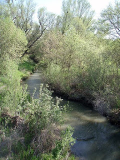 • 20 Putah Creek.
 • 03 Wild radish - Raphanus raphanistrum.
• More photos: BRT photos from South Fork Putah Creek Preserve.
Most of the South Fork Putah Creek Preserve is an open grassland that won't be very interesting until a lot more habitat restoration is completed. The Outer Loop and Inner Loop Trails have no shade and are mostly straight, flat, boring hiking between two barbed wire fences.
For more information:
• Putah Creek Watershed Directory - Recreation & Conservation. Websites for the Putah Creek Valley. (Sort alphabetically. 1&2=kayaking-rafting-canoeing-paddlesports, 3=conservation-environment, 4=fishing, 5=camping-hiking, 6=local-websites)
• Map & driving directions - South Fork Putah Creek Preserve - MapQuest.
• Researchers Determine Genetic Origin Of California Wild Radish - sciencedaily 19july2006.
• Flow Data for Putah Creek near Winters CA - USGS.
• Putah Creek Council.
• Hiking & Camping Trip Reports - BRT Insights.
• Olympus Stylus 720SW camera. Photos edited with IrfanView software.
IceRocket Tags: hiking, Sacramento Valley, Putah Creek, Yolo County, California.
Tags: wildflowers, photography, landscape photography.
Map of South Fork Putah Creek Preserve & nearby& landmarks.
• Instructions for online interactive topographic maps & road maps.• Click on Map button for road map, Topo button for topographic map.
• Full-Screen Map - South Fork Putah Creek Preserve & surroundings.
Wild radishes as well as a few types of microflora were blooming.
DoubleClick on photos to see larger images. Use back button to return.


• More photos: BRT photos from South Fork Putah Creek Preserve.
Most of the South Fork Putah Creek Preserve is an open grassland that won't be very interesting until a lot more habitat restoration is completed. The Outer Loop and Inner Loop Trails have no shade and are mostly straight, flat, boring hiking between two barbed wire fences.
Nearby hiking, biking & jogging opportunities.
West of Co Rd 104 the dirt roads that parallel Putah Creek on the north & the south both appear to be open for hiking & biking. I saw some joggers going on a trail that goes along the treeline even closer to the north side of the creek. The north side Levee Rd connects back to Davis via Drummond Ln and via Old Davis Rd.For more information:
• Putah Creek Watershed Directory - Recreation & Conservation. Websites for the Putah Creek Valley. (Sort alphabetically. 1&2=kayaking-rafting-canoeing-paddlesports, 3=conservation-environment, 4=fishing, 5=camping-hiking, 6=local-websites)
• Map & driving directions - South Fork Putah Creek Preserve - MapQuest.
• Researchers Determine Genetic Origin Of California Wild Radish - sciencedaily 19july2006.
• Flow Data for Putah Creek near Winters CA - USGS.
• Putah Creek Council.
• Hiking & Camping Trip Reports - BRT Insights.
• Olympus Stylus 720SW camera. Photos edited with IrfanView software.
IceRocket Tags: hiking, Sacramento Valley, Putah Creek, Yolo County, California.
Tags: wildflowers, photography, landscape photography.
Labels: hiking
Tuesday, March 23, 2010
Marshall Gold State Historic Park closed to all raft & kayak put-ins until Memorial Day 2010.
I called Marshall Gold SHP and they said that North Beach Picnic Area is closed until Memorial Day weekend 2010. That means no parking and no whitewater boat launching at this popular put-in for the Coloma to Greenwood Run on SF American River (El Dorado County, California, USA.)
Alternate put-in locations for the remainder of the spring boating season are the Hwy 49 bridge or Henningson Lotus Park.
For more information:
Fight the Closure of Marshall Gold Discovery SHP - access point for SF American River 28aug2009.
IceRocket Tags: river, California, American River, El Dorado County.
Tags: whitewater, kayaking, rafting, canoeing, paddle boating, paddlesport.
Labels: guide
Monday, March 22, 2010
Capay Valley & Bear Valley wildflowers - Yolo County & Colusa County, California USA 20mar2010.
JimH & I did a wildflower drive-around on 20mar2010. Fruit tree blossoms in Capay Valley were a little past their prime, but were still quite nice. There were also blooms on redbuds, mustards and many others. We continued north on Hwy 16 along Cache Creek and Bear Creek.
• Click on Map button for road map, Topo button for topographic map.
• Full-Screen Map - landmarks along Capay Valley & Bear Valley.
• Names of landmarks (A, B, etc.) - DoubleClick or point on the red
markers.
N 38.70748 W 122.09793 - Capay Valley (A)
N 39.01201 W 122.36079 - Hwy 20 x Bear Valley Rd
N 39.04029 W 122.40825 - Bridge over Bear Ck
N 39.07231 W 122.40963 - south end of Bear Valley wildflower area (B)
N 39.17801 W 122.44310 - Bear Valley Buttes at north end of valley (C)
N 39.18956 W 122.42126 - Leesville Gap to High Valley (D)
N 39.14184 W 122.34298 - Leesville Rd at Mountain House
N 38.85468 W 122.04300 - Bird Valley & Dunnigan Hills
N 38.71230 W 122.04575 - Capay Open Space Park
N 38.52497 W 121.97041 - El Verduzco Taco Truck, Winters, CA
 • 06 Black Mustard (Brassica nigra), Capay Valley wildflowers.
 • 61 Bear Valley wildflowers, Colusa County.
 • 91 High Valley wildflowers, Colusa County.
 • 124 California Poppy (Eschscholzia californica), Bird Valley, Dunnigan Hills wildflowers, Yolo County.
• More photos: BRT photos from Bear Valley, JimH photos from Bear Valley.
We got on Interstate Hwy 5 heading south and took one more sidetrip through Bird Valley & the Dunnigan Hills. This area is all planted in grain, so there were almost no wildflowers. There were some horticultural varieties of California poppy planted by the roadside that provided a few nice, colorful flower displays. Capay Open Space Park provides a public access to Cache Creek. Finally we got some excellent tacos from the El Verduzco Taco Truck located on E. Grant Ave. just east of the Railroad Ave. intersection in Winters, CA.
For more information:
• Bear Valley wildflowers - Colusa County - Davis Wiki
• Colusa County Trailheads Map - BRT Insights.
• Bear Creek Recreation & Conservation Directory. (Sort alphabetically. Section 5 = camping & hiking)
• Hiking & Camping Trip Reports - BRT Insights.
• Olympus Stylus 720SW camera. Photos edited with IrfanView
software.
IceRocket Tags: hiking, Capay Valley, Cache Creek, Yolo County, Bear Creek, Colusa County, California.
Tags: wildflowers, photography, landscape photography.
Map of Bear Valley & nearby landmarks.
• Instructions for online interactive topographic maps & road maps.• Click on Map button for road map, Topo button for topographic map.
• Full-Screen Map - landmarks along Capay Valley & Bear Valley.
• Names of landmarks (A, B, etc.) - DoubleClick or point on the red
markers.
N 38.70748 W 122.09793 - Capay Valley (A)
N 39.01201 W 122.36079 - Hwy 20 x Bear Valley Rd
N 39.04029 W 122.40825 - Bridge over Bear Ck
N 39.07231 W 122.40963 - south end of Bear Valley wildflower area (B)
N 39.17801 W 122.44310 - Bear Valley Buttes at north end of valley (C)
N 39.18956 W 122.42126 - Leesville Gap to High Valley (D)
N 39.14184 W 122.34298 - Leesville Rd at Mountain House
N 38.85468 W 122.04300 - Bird Valley & Dunnigan Hills
N 38.71230 W 122.04575 - Capay Open Space Park
N 38.52497 W 121.97041 - El Verduzco Taco Truck, Winters, CA
Peak wildflower display at Bear Valley predicted for first week of April 2010.
Wildflowers were quite sparse at the south end of Bear Valley, but fortunately we kept going north. Some people we met up there estimated that it would be about 2 weeks before the peak wildflower bloom would occur in Bear Valley this year. Nevertheless, there were some very nice wildflower displays at the north ends of Bear Valley and High Valley. All of this land is private and fenced, so we stopped at various places along the road and got out to view & photograph the wildflowers. Then we saw some roadside wildflowers in Oat Valley and Antelope Valley as we headed east towards the Sacramento Valley.


• More photos: BRT photos from Bear Valley, JimH photos from Bear Valley.
We got on Interstate Hwy 5 heading south and took one more sidetrip through Bird Valley & the Dunnigan Hills. This area is all planted in grain, so there were almost no wildflowers. There were some horticultural varieties of California poppy planted by the roadside that provided a few nice, colorful flower displays. Capay Open Space Park provides a public access to Cache Creek. Finally we got some excellent tacos from the El Verduzco Taco Truck located on E. Grant Ave. just east of the Railroad Ave. intersection in Winters, CA.
For more information:
• Bear Valley wildflowers - Colusa County - Davis Wiki
• Colusa County Trailheads Map - BRT Insights.
• Bear Creek Recreation & Conservation Directory. (Sort alphabetically. Section 5 = camping & hiking)
• Hiking & Camping Trip Reports - BRT Insights.
• Olympus Stylus 720SW camera. Photos edited with IrfanView
software.
IceRocket Tags: hiking, Capay Valley, Cache Creek, Yolo County, Bear Creek, Colusa County, California.
Tags: wildflowers, photography, landscape photography.
Labels: hiking
Saturday, March 06, 2010
California Hiking Trails Directory Pg. 4
• Pg. 1 - Personal Websites on Hiking in California.
• Pg. 2 - National, State & Regional Parks in California.
• Pg. 3 - County Parks in California.
• Pg. 4 - Hiking Trails Listed by Counties & Regions in California.
• Pg. 5 - Hiking Clubs in California.
• Pg. 6 - Photos from Hiking in California.
More about:
• California map showing county boundaries - mapsofworld.
• Maps of individual counties in California - mapsofworld.
• Hiking Trip Reports - BRT Insights.
• Contact me about sites to add to this California Hiking Directory.
• Site Map - BRT Insights - Kayaking & Hiking in California.
IceRocket Tags: hiking, trail, California.
Tags: photography, panoramic photography, landscape photography.
• Pg. 2 - National, State & Regional Parks in California.
• Pg. 3 - County Parks in California.
• Pg. 4 - Hiking Trails Listed by Counties & Regions in California.
• Pg. 5 - Hiking Clubs in California.
• Pg. 6 - Photos from Hiking in California.
Hiking Trails Listed by County on Wiki Websites in California.
Extensive lists of hiking trails and hiking areas are being organized on wiki websites. Everybody can register on the wikis and add their knowledge of hiking trails in California.California Hiking Trails Directory
• Personal Sites > Statewide Parks > County Parks > *Wiki Sites* > Hiking Groups > Photos.More about:
• California map showing county boundaries - mapsofworld.
• Maps of individual counties in California - mapsofworld.
• Hiking Trip Reports - BRT Insights.
• Contact me about sites to add to this California Hiking Directory.
• Site Map - BRT Insights - Kayaking & Hiking in California.
IceRocket Tags: hiking, trail, California.
Tags: photography, panoramic photography, landscape photography.
Friday, March 05, 2010
Testing Some Widgets
Here are some widgets that I just found.
More about:
• About My Blog and About Blogging - BRT Kayaking & Hiking.
• Tips for Blog Writers - BRT Kayaking & Hiking.
• About My Blog and About Blogging - BRT Kayaking & Hiking.
• Tips for Blog Writers - BRT Kayaking & Hiking.
Labels: blog
Thursday, March 04, 2010
California Hiking Trails Directory Pg. 3
• Pg. 1 - Personal Websites on Hiking in California.
• Pg. 2 - National, State & Regional Parks in California.
• Pg. 3 - County Parks in California.
• Pg. 4 - Hiking Trails Listed by Counties & Regions in California.
• Pg. 5 - Hiking Clubs in California.
• Pg. 6 - Photos from Hiking in California.
Alameda County - Eastbay Parks District
Butte County Recreation
Calaveras County Visitors Bureau Hiking Trails
Contra Costa County - Eastbay Parks District
Contra Costa County - City of Lafayette Hiking Trails
El Dorado County parks
Lake County Trails & Paths
Lake County Parks & Recreation
Marin County Recreation Resources
Marin County Open Space District
Marin County Parks and Open Space
Mendocino County Parks
Napa County Regional Park and Open Space District
Nevada County - Truckee Trails Foundation
Placer County Parks & Trails
Placer County Visitor’s Bureau
Sacramento County Regional Parks
San Francisco Recreation & Park Department
San Mateo County - Department of Parks
Santa Clara County Open Space Authority
Santa Clara County - Parks and Recreation.
Santa Cruz County Parks Department
Shasta County Public Works
Solano County Parks
Solano Land Trust
Sonoma County Open Space District
Sonoma County - LandPaths
Sonoma County Recreation - sonoma.net
Sonoma County Regional Parks
Sutter County Recreational Facilities
Yolo County : Parks & Resources
Yuba County Parks
More about:
• California map showing county boundaries - mapsofworld.
• Maps of individual counties in California - mapsofworld.
• Contact me about sites that should be added to the directory or PageRanks (PR) that need updating.<>
• Hiking Trip Reports - BRT Insights.
• Site Map - BRT Insights - Kayaking & Hiking in California.
IceRocket Tags: hiking, trail, California.
Tags: photography, panoramic photography, landscape photography.
• Pg. 2 - National, State & Regional Parks in California.
• Pg. 3 - County Parks in California.
• Pg. 4 - Hiking Trails Listed by Counties & Regions in California.
• Pg. 5 - Hiking Clubs in California.
• Pg. 6 - Photos from Hiking in California.
County Park Trails & Hiking Areas
County governments provide many small parks where hiking and outdoor recreation can be done.Alameda County - Eastbay Parks District
Butte County Recreation
Calaveras County Visitors Bureau Hiking Trails
Contra Costa County - Eastbay Parks District
Contra Costa County - City of Lafayette Hiking Trails
El Dorado County parks
Lake County Trails & Paths
Lake County Parks & Recreation
Marin County Recreation Resources
Marin County Open Space District
Marin County Parks and Open Space
Mendocino County Parks
Napa County Regional Park and Open Space District
Nevada County - Truckee Trails Foundation
Placer County Parks & Trails
Placer County Visitor’s Bureau
Sacramento County Regional Parks
San Francisco Recreation & Park Department
San Mateo County - Department of Parks
Santa Clara County Open Space Authority
Santa Clara County - Parks and Recreation.
Santa Cruz County Parks Department
Shasta County Public Works
Solano County Parks
Solano Land Trust
Sonoma County Open Space District
Sonoma County - LandPaths
Sonoma County Recreation - sonoma.net
Sonoma County Regional Parks
Sutter County Recreational Facilities
Yolo County : Parks & Resources
Yuba County Parks
CA Hiking Directory.
• Personal Hiking > Statewide Parks > *County Parks* > Wiki Hiking > Hiking Groups > Photos)More about:
• California map showing county boundaries - mapsofworld.
• Maps of individual counties in California - mapsofworld.
• Contact me about sites that should be added to the directory or PageRanks (PR) that need updating.<>
• Hiking Trip Reports - BRT Insights.
• Site Map - BRT Insights - Kayaking & Hiking in California.
IceRocket Tags: hiking, trail, California.
Tags: photography, panoramic photography, landscape photography.
Monday, March 01, 2010
California Hiking Trails Directory Pg. 2
National, State & Regional Parks & Hiking Areas
(updated Jan 5, 2012)• Pg. 1 - Personal Websites on Hiking in California.
• Pg. 2 - National, State & Regional Parks in California.
• Pg. 3 - County Parks in California.
• Pg. 4 - Hiking Trails Listed by Counties & Regions in California.
• Pg. 5 - Hiking Clubs in California.
• Pg. 6 - Photos from Hiking in California.
Parks, Monuments and Recreation Areas in California.
Many government and non-government organizations manage lands in California that are open for public recreation.More about:
• CA Hiking Directory (Personal Hiking > *Statewide Parks* > County Parks > Wiki Hiking > Hiking Groups > Photos)
• Contact me about new sites for the directory.
• Site Map - BRT Insights - Kayaking & Hiking in California.
IceRocket Tags: hiking, trail, California.
Tags: photography, panoramic photography, landscape photography.
![]()


