Thursday, December 30, 2010
Fairy Falls Trail, Spenceville Wildlife Area hiking trip report - Nevada County, California USA.
(29dec2010) A sunny day immediately after a rainstorm is a great time to go hiking. And even more so if your hiking destination is a waterfall. We debated going to another more famous falls along the coast, but I think we made the right choice.
Double-click on the photos to see the large version, then use the back button to return.
 • Fairy Falls Trail at Spenceville Wildlife Area.
 • Upper Fairy Falls at Spenceville Wildlife Area.
• More BRT photos: Spenceville Wildlife Area hiking photos 2010-12-29.
• Fairy Falls, Spenceville Wildlife Area photos with map locations - brthomas.
• Olympus Stylus 720SW camera. Photos edited with IrfanView software.
• Fairy Falls (a.k.a. Shingle Falls) photos - JimH.
• Fairy Falls (a.k.a. Shingle Falls) photos with map locations - EveryTrail - ElRemaro
• Pentax Optio W10 waterproof camera.
• Mapping Methods and GPS Equipment for Travel Photography.
Whoever named this place Fairy Falls must have been there in the summertime, perhaps when minimal creek flows might provide delicate little trickling waterfalls. After a big winter rainstorm there is nothing delicate about these roaring mighty waterfalls! The USGS gage height on Dry Creek was at 11 feet on the day when we hiked there.
• BRT video taken with Olympus Stylus 850SW waterproof camera.
Returning from the falls we climbed up the hill and hiked back on the Upper Loop Trail. From there we got some good views of Sutter Buttes. Then on the drive home we took a scenic detour to get a close-up look at the south side of Sutter Buttes.
• Use the tool on the left to zoom in and out. Point on the red markers to see their names.
• Map button = road map. Terrain = 3D shaded topo map. Topo = topographic map.
• Full-Screen Road and Topographic Map: Fairy Falls and Spenceville Wildlife Area.
N 39.11395 W 121.27104- Trailhead (A)
N 39.11498 W 121.24293 - Fairy Falls (B)
N 39.02638 W 121.43611 - USGS Dry Creek flow gauge (C)
N 39.20572 W 121.82027 - Sutter Buttes (D)
For more information:
• Spenceville Wildlife Area Hiking Trails Map - Sierra Outdoor Recreation.
• Fairy Falls - Yuba-Sutter Wiki.
• Friends of Spenceville Wildlife Area.
• Spenceville Wildlife Area - CA Dept Fish and Game.
• Hiking, Camping and Biking Trip Reports - BRT Insights.
• California Hiking Trails - Statewide Information.
• California Maps - Atlas & Gazetteer by Delorme, 2008.
IceRocket Tags: hiking, Fairy Falls, Spenceville Wildlife Area, Nevada County, California.
Tags: waterfalls, photography, landscape photography.
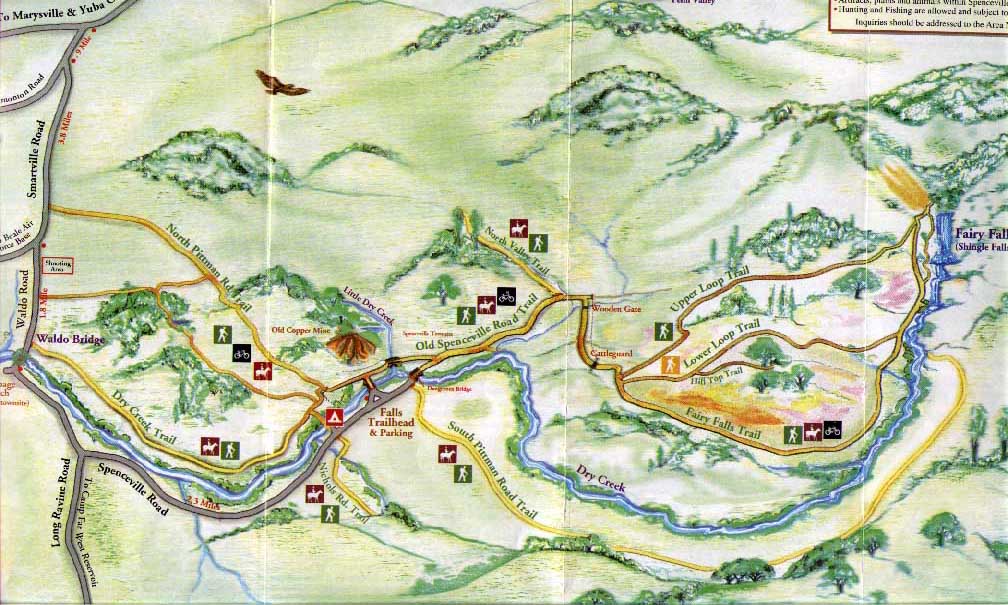
Spenceville Wildlife Area hiking trails.
We hiked out to the falls on the Fairy Falls Trail. See the trails map from Friends of Spenceville. (Use the back button to return.) Fall, winter & spring are great times for hiking at Spenceville Wildlife Area in the Sacramento Valley. The oak woodland habitat is excellent for hiking. Elevation at the trailhead is 280 feet. On a cool day the hiking trails that are mostly or entirely exposed to the sun are delightful, but I can imagine that it would be brutal to hike there on a hot summer day. I used grape juice & black tea in my homemade energy-sports drink recipe for hydration while hiking. Even with a favorite tasty mixture to drink I unfortunately fell back into my bad old habit of not drinking enough during the hike.Double-click on the photos to see the large version, then use the back button to return.

Fairy Falls (a.k.a. Shingle Falls, Dry Creek Falls, Beale Falls).
Our main objective for the day was to hike to Fairy Falls on Dry Creek. The headwaters for Dry Creek are in eastern Nevada County on the north-west side of Sugar Loaf Mountain. Flowing west out of the Sierra foothills, the Dry Creek watershed is north of the Bear River and south of the Yuba River. The USGS flow gauge on Dry Creek is more than 10 miles downstream from Fairy Falls. Checking this flow level before you hike is a good way to predict the kind of flow you'll see at the falls. Dry Creek joins the Bear River just upstream from the Bear River confluence with the Feather River south-west of Wheatland, CA. The last stretch of road on the drive to the trailhead is on Spenceville Road which runs along Dry Creek. The flow you see there is another way to judge the kind of flow you'll see when you hike upstream to Fairy Falls.
• More BRT photos: Spenceville Wildlife Area hiking photos 2010-12-29.
• Fairy Falls, Spenceville Wildlife Area photos with map locations - brthomas.
• Olympus Stylus 720SW camera. Photos edited with IrfanView software.
• Fairy Falls (a.k.a. Shingle Falls) photos - JimH.
• Fairy Falls (a.k.a. Shingle Falls) photos with map locations - EveryTrail - ElRemaro
• Pentax Optio W10 waterproof camera.
• Mapping Methods and GPS Equipment for Travel Photography.
Whoever named this place Fairy Falls must have been there in the summertime, perhaps when minimal creek flows might provide delicate little trickling waterfalls. After a big winter rainstorm there is nothing delicate about these roaring mighty waterfalls! The USGS gage height on Dry Creek was at 11 feet on the day when we hiked there.
• BRT video taken with Olympus Stylus 850SW waterproof camera.
Returning from the falls we climbed up the hill and hiked back on the Upper Loop Trail. From there we got some good views of Sutter Buttes. Then on the drive home we took a scenic detour to get a close-up look at the south side of Sutter Buttes.
Road Map and Topographic Map - Spenceville Wildlife Area.
• Map user FAQ. The map is interactive. Click and drag to reposition map.• Use the tool on the left to zoom in and out. Point on the red markers to see their names.
• Map button = road map. Terrain = 3D shaded topo map. Topo = topographic map.
• Full-Screen Road and Topographic Map: Fairy Falls and Spenceville Wildlife Area.
N 39.11395 W 121.27104- Trailhead (A)
N 39.11498 W 121.24293 - Fairy Falls (B)
N 39.02638 W 121.43611 - USGS Dry Creek flow gauge (C)
N 39.20572 W 121.82027 - Sutter Buttes (D)
For more information:
• Spenceville Wildlife Area Hiking Trails Map - Sierra Outdoor Recreation.
• Fairy Falls - Yuba-Sutter Wiki.
• Friends of Spenceville Wildlife Area.
• Spenceville Wildlife Area - CA Dept Fish and Game.
• Hiking, Camping and Biking Trip Reports - BRT Insights.
• California Hiking Trails - Statewide Information.
• California Maps - Atlas & Gazetteer by Delorme, 2008.
IceRocket Tags: hiking, Fairy Falls, Spenceville Wildlife Area, Nevada County, California.
Tags: waterfalls, photography, landscape photography.
Saturday, December 25, 2010
San Gabriel River Whitewater Guide and Map for Paddle Boating - California USA.
Canoeing, Rafting, Innertubing & Kayaking Paddlesport - Los Angeles County.
San Gabriel River Whitewater Boating Runs - put-ins and other landmark locations.
1 San Gabriel River WF, Second Bridge to San Gabriel Reservoir, class IV, 2.5 miles.2. San Gabriel River EF, Eldoraville Camp to Reservoir, class III/IV, 4 Miles.
3. San Gabriel River, Morris Dam to Foothill Blvd, class II ??, 5.5 Miles.
Real-time Flow - San Gabriel River whitewater.
Flow gauges are on the map. Does anybody know how to find the data from the gauges online?River Map - access locations for San Gabriel River paddle boating.
• Map user FAQ. The map is interactive. Click and drag to reposition map.• Use the tool on the left to zoom in and out. Point on the red markers to see their names.
• Map button = road map. Terrain = 3D shaded topo map. Topo = topographic map.
• Full-Screen River Map: San Gabriel River access and flow gauge locations .
Geographic coordinates - Landmark name (marker on map above)
-- San Gabriel River. --
1 San Gabriel River WF, Second Bridge to San Gabriel Reservoir, class IV, 2.5 miles.
N 34.24026 W 117.89351 - Second bridge put-in (A)
N 34.24140 W 117.86330 - Gauge - can we find the data online? (B)
N 34.23976 W 117.85704 - San Gabriel Reservoir take-out (C)
2. San Gabriel River EF, Eldoraville Camp to Reservoir, class III/IV, 4 Miles.
N 34.22944 W 117.77189 - Eldoraville Camp (D)
N 34.23583 W 117.80653 - Gauge - can we find the data online? (E)
N 34.23811 W 117.82060 - Fire Camp bridge (F)
3. San Gabriel River, Morris Dam to Foothill Blvd, class II ??, 5.5 Miles.
N 34.17204 W 117.88605 - Morris Dam put-in (G)
N 34.13717 W 117.94304 - Foothill Blvd take-out (H) Gauge - can we find the data online?
Driving Directions, Map, Distance, Estimated Time & Road Conditions.
Mapquest provides directions, distance & time from your house to the river.• From Davis, CA to Azusa, CA - driving time 6 hrs 22 mins - 411 miles.
California Road Conditions (Delays or closures due to weather, construction, etc.)
• California Travel Information - highwayconditions.com.
• Road Conditions - California Dept Transportation.
Local weather in Azusa, CA (elevation 841 feet).

Online River Guides & River Flow Data for Paddleboating.
• Directory for Paddle Boating on the San Gabriel River. (See section 1.)Printed Guidebooks & Maps - San Gabriel River whitewater.
• None.San Gabriel River Boating Stories REQUESTED !!
Contact me to submit your San Gabriel River trip report. I welcome whitewater boating trip stories, pictures & videos from guest authors. I will post or link to your trip reports.• Kayaking the West Fork of the San Gabriel River video - surfnturf57 13feb2010.
• West Fork San Gabriel River Part I video - surfnturf57 05mar2010.
Whitewater River Recreation & Environment.
• San Gabriel River Valley Conservation & Recreation Directory. Websites for the San Gabriel River watershed. Set display options - alphabetical 100. Section 1=kayaking-canoeing, 2=rafting-tubing, 3=environment-conservation, 4=fishing, 5=hiking-camping, 6=other-resources)More about:
• Rivers & creeks nearby: Santa Ynez River, (Santa Clara River, Piru Creek, Sespe Creek).
• Central & South Coast Paddleboating Guides for California Rivers.
• Canoeing, Kayaking & Rafting Paddlesport Guides for California Whitewater Rivers.
• How to use these whitewater river kayaking and rafting guides - BRT Insights.
IceRocket Tags: kayaking, socal, Southern California, river map, river tubing, float tube.
Tags: San Gabriel River, California, Los Angeles County, rafting, canoeing, whitewater, kayaking, paddle boating, river.
Labels: guide
Friday, December 24, 2010
Muir Woods National Monument - hiking the trails to see the redwood trees - Marin County, California USA.
Muir Woods is a place where Mother Nature is large and people feel humble.

"Muir Woods National Mounment is a remnant of ancient coast redwood forests that blanketed many northern California coastal valleys before the 1800s. Local businessman William Kent and his wife Elizabeth Thatcher Kent bought land in this valley in 1905 to protect one of the last stands of uncut redwoods. To ensure permanent protection, they donated 295 acres of redwoods to the federal government. In 1908 President Theodore Roosevelt proclaimed the area a national monument. At William Kent's request, it was named for the conservationist John Muir." From the Muir Woods National Monument brochure.
"I only went out for a walk, and finally concluded to stay out till sundown, for going out, I found, was really going in." John Muir. See the music video by Steve Eulberg - Walk in the Redwood Forest Cathedral at Muir Woods National Monument.
"This is the best tree-lover's monument that could possibly be found in all the forests of the world" John Muir
"God has cared for these trees, saved them from drought, disease, avalanches, and a thousand, straining, leveling tempests and floods, but he cannot save them from fools - only Uncle Sam can do that." John Muir
"In every walk with Nature, one receives far more than [one] seeks" John Muir

• More BRT photos: Muir Woods National Monument photos 2010-12-23.
• Olympus Stylus 720SW camera. Photos edited with IrfanView software.
• JimH photos: Muir Woods hiking photos - JimH 23dec2010.
Sunny day delight after a rainstorm at Muir Woods National Monument.
Hiking on the first sunny day after a long period of rain was a magical experience. When JimH, KimF and CarolynD agreed to hike at Muir Woods I had a moment of regret, thinking that perhaps it would have been a better day to hike to a big waterfall somewhere else. That was not a problem because at Muir Woods we found Redwood Creek, Fern Creek and many smaller creeks gushing noisily down the hillsides making a multitude of small waterfalls.We started out hiking on the Main Trail along Redwood Creek and then turned off on the Fern Creek Trail. At these lower elevations the trail goes through the most incredible old growth redwood forest. For hydration while hiking I used my PowerT Hydration Juice energy-sports drink recipe made with black tea and Northland Superfruits 100% Juice.
Mount Tamalpais State Park.
As the Fern Creek Trail continues up the canyon at some point we left the redwood forest and crossed into Mount Tamalpais State Park. At Camp Eastwood we picked up the Sierra Trail and continued climbing up, up, up the canyon to find some sunny places with great views. The Troop 80 Trail traverses across the canyon wall with little change in elevation while crossing many noisy little creeks rushing down the hillside. We had a quick lunch at Van Wyck Meadow and then continued on Alpine Trail and T.C.C. Trail. When it was time to hike out we reentered Muir Woods National Monument on the Ben Johnson Trail and hiked steeply down the canyon back to the Main Trail and the main entrance.Hiking Map - trails at Muir Woods National Monument.
• Map user FAQ. The map is interactive. Click and drag to reposition map.• Use the tool on the left to zoom in and out. Point on the red markers to see their names.
• Map button = road map. Terrain = 3D shaded topo map. Topo = topographic map.
• Full-Screen Trail Map: Muir Woods National Monument and Mount Tamalpais State Park.
For more information:
• Map and trailheads for Muir Woods National Monument - Marin County.
• Hiking trails in Marin County - Marin Wiki.
• Hiking, Camping and Biking Trip Reports - BRT Insights.
• California Hiking Trails - Statewide Information.
• California Maps - Atlas & Gazetteer by Delorme, 2008.
IceRocket Tags: hiking, trails, Muir Woods National Monument, Mount Tamalpais State Park, Marin County, California.
Tags: redwood trees, photography, landscape photography.
Labels: hiking
Monday, December 20, 2010
Russian River Flatwater Paddleboating Map and Guide - California USA.
Canoeing, Kayaking, Rafting and Innertubing Paddlesport - Sonoma County.
The lower Russian River gets fast, high flows in the winter/spring rainy season. Most boating on this section of river is done in the summer when the river has a calm, gentle flow of flatwater.Russian River Watershed Flatwater Boating Runs.
• Russian River, Cloverdale to Pacific Ocean, class 1, 62 miles.• Mark West Creek Lower Run, class I ??, ~12 miles.
• Austin Creek Run, class I+, 7.5 miles.
Real-time Flow - Lower Russian River flatwater.
Use the flow gauge that is closest to the section of river that you plan to paddle. See red location markers on map below.• Russian River gauge nr Cloverdale - USGS Real-Time Water Flow Data (A)
• Russian River gauge nr Healdsburg - USGS Real-Time Water Flow Data (E)
• Russian River gauge nr Guerneville - USGS Real-Time Water Flow Data (H)
• Austin Creek gauge nr Cazadero - USGS Real-Time Water Flow Data (N)
River Map - access locations for lower Russian River paddle boating.
• Map user FAQ. The map is interactive. Click and drag to reposition map.• Use the tool on the left to zoom in and out. Point on the red markers to see their names.
• Map button = road map. Terrain = 3D shaded topo map. Topo = topographic map.
• Full-Screen River Map: lower Russian River access and flow gauge locations .
Geographic coordinates - Landmark name (marker on map above)
--- Russian River ---
1. Cloverdale to Asti Run, class I, 6 miles.
N 38.88215 W 123.05518 - Russian River gauge nr Cloverdale (A)
N 38.80898 W 123.00789 - Cloverdale put-in (B)
N 38.76335 W 122.96868 - Asti take-out (C)
2. Asti to Alexander Valley Rd Run, class I, 10.5 miles.
N 38.76335 W 122.96868 - Asti put-in (C)
N 38.65871 W 122.82964 - Alexander Valley Rd take-out (D)
3. Alexander Valley Rd to Healdsburg Run, class I, 14.6 miles.
N 38.65871 W 122.82964 - Alexander Valley Rd put-in (D)
N 38.61327 W 122.83633 - Russian River gauge nr Healdsburg (E)
N 38.60118 W 122.85929 - Healdsburg take-out (F)
4. Healdsburg to Mirabel Pk Run, class I, 10.1 miles.
N 38.60118 W 122.85929 - Healdsburg put-in (F)
N 38.49407 W 122.89526 - Mirabel Pk take-out (G)
5. Mirabel Pk to Guerneville Run, class I, 8.6 miles.
N 38.49407 W 122.89526 - Mirabel Pk put-in (G)
N 38.50847 W 122.92770 - Russian River gauge nr Guerneville (H)
N 38.51110 W 122.98388 - Guerneville take-out (I)
6. Guerneville to Austin Ck Run, class 1, 6.7 miles.
N 38.51110 W 122.98388 - Guerneville put-in (I)
N 38.46078 W 123.05271 - Austin Ck take-out (J)
7. Austin Ck to Willow Ck Run, class 1, ~5 miles.
N 38.46078 W 123.05271 - Austin Ck put-in (J)
N 38.44004 W 123.09601- Willow Ck take-out (K)
--- Russian River Tributaries runnable in the rainy season ---
8. Mark West Creek Lower Run, class ??, ~12 miles.
N 38.50551 W 122.72964 - put-in (L) ??
N 38.49407 W 122.89526 - Mirabel Pk take-out (G) ??
9. Austin Creek Run, class I+, 7.5 miles.
N 38.54333 W 123.08807 - put-in (M)
N 38.50667 W 123.06863 - Austin Creek gauge nr Cazadero (N)
N 38.47133 W 123.04619 - take-out (O)
Driving Directions, Map, Distance, Estimated Time & Road Conditions.
Mapquest provides directions, distance & time from your house to the river.• From Davis, CA to Guerneville, CA - driving time 2 hrs - 108 miles.
California Road Conditions (Delays or closures due to weather, construction, etc.)
• California Travel Information - highwayconditions.com.
• Road Conditions - California Dept Transportation.
Local weather in Guerneville, California (elevation 55 feet).

Online River Guides & River Flow Data for Paddleboating.
• Directory for Paddle Boating on the Russian River. (See section 1.)Printed Guidebooks & Maps - Russian River flatwater.
• Ann Dwyer's Easy Waters of California North, 2000. (pg. 68-81, Cloverdale to ocean, Austin Creek)• West Coast River Touring - Rogue River Canyon and South, 1974. (pg. 173-182, Cloverdale to Austin Ck confluence)
• Down the Wild Rivers- A Guide to the Streams of California, 1972. (pg. 200-205, Cloverdale to ocean)
Russian River Boating Stories REQUESTED !!
Contact me to send in your Russian River trip report. I appreciate paddleboating trip stories, pictures & videos from guest authors. I am interested to post or link to your trip reports.• Just around the Riverbend…Again! - dollybeast 19june2011
• Russian River Canoeing - Tyrrell's Site Oct. 2010.
• Russian River Kayaking photos - gaylainberkeley 25july2010
• Ridiculously Rad Russian River Rafting - dollybeast june2010
• Wine by Canoe? - Left Coast Wanders 25feb2010.
• Google Image Search - Russian River California (kayaking OR canoeing OR rafting OR tubing).
• See older trip reports: Russian River Boating Overview.
Russian River Canoeing & Kayaking Videos.
• Rock Diving - Russian River Canoe trip - mashimomo 31may2011• Russian River Canoe & Kayak video - kaisergecko 06aug2010.
• Kayaking along the Russian River - elementsaustincreek 08june2010
• Google Videos - Russian River" (kayaking OR canoeing OR rafting).
• YouTube - Russian River" (kayaking OR canoeing OR rafting).
• See older videos: Russian River Boating Overview.
Flatwater River Recreation & Environment.
• Russian River Watershed Recreation and Conservation Directory. Websites for the Russian River valley. Set display options - alphabetical 100. Section 1=kayaking-canoeing, 2=rafting-tubing, 3=environment-conservation, 4=fishing, 5=hiking-camping, 6=other-resources)More about:
• Rivers nearby: Gualala River, Eel River, Petaluma River.
• North Coast California River Guides for Paddleboating.
• Canoeing, Kayaking & Rafting Paddlesport Guides for California Whitewater Rivers.
• Use of this guide for river kayaking and rafting - BRT Insights.
IceRocket Tags: kayaking, river map, river tubing, float tube.
Tags: flatwater, Russian River, Mark West Creek, Austin Creek, California, Sonoma County, rafting, canoeing, kayaking, paddle boating, river.
Labels: guide
Sunday, December 19, 2010
Russian River Whitewater Map and Guide for Paddleboating - California USA.
Canoeing, Rafting, Innertubing & Kayaking Paddlesport - Mendocino County & Sonoma County.
Whitewater on the upper Russian River runs in the winter/spring rainy season, excepting the EF Russian River which also runs in summer due to a diversion from the Eel River.Russian River Whitewater Boating Runs - put-ins and other landmark locations.
1. Russian River EF, class III, 2.6 miles. (flows in the summer due to Eel River water diversions)(beware of the mandatory portage just upstream from the put-in)2. Coyote Dam to Talmage Run, class II, 4.5 miles.
3. Talmage to Hopland Run, class I+, 14.5 miles.
4. Hopland to Pieta Creek Run, class I-II, 5 miles.
5. Pieta Creek to Cloverdale, class II-III, 11 miles. (Squaw Rock Run)
6. Mark West Creek Upper Run, class III-V, 4 miles.
Real-time Flow - Upper Russian River whitewater.
Flows can vary dramatically in different segments of the river depending upon diversions and local patterns of recent rainfall. Use the flow gauge that is closest to the section of river that you plan to paddle. See red location markers on map below.• EF Russian River nr Calpella - USGS Real-Time Water Flow Data. inflow to Lake Mendocino (B)
• EF Russian River nr Ukiah - USGS Real-Time Water Flow Data. outflow from Lake Mendocino(D)
• Russian River nr Ukiah - USGS Real-Time Water Flow Data. above confluence with EF Russian R (C)
• Russian River nr Talmage - USGS Real-Time Water Flow Data. (F)
• Russian River nr Hopland - USGS Real-Time Water Flow Data. (G)
• Russian River nr Cloverdale - USGS Real-Time Water Flow Data. (J)
River Map - access locations for upper Russian River paddle boating.
• Map user FAQ. The map is interactive. Click and drag to reposition map.• Use the tool on the left to zoom in and out. Point on the red markers to see their names.
• Map button = road map. Terrain = 3D shaded topo map. Topo = topographic map.
• Full-Screen River Map: Russian River access and flow gauge locations .
Geographic coordinates - Landmark name (marker on map above)
--- EF Russian River. ---
1. Russian River EF, class III, 2.6 miles. (flows in the summer due to Eel River water diversions)
N 39.26077 W 123.11215 - put-in (A)
N 39.24439 W 123.13363 - gauge inflow to Lake Mendocino (B)
N 39.23671 W 123.15176 - take-out.
--- Russian River - Main. ---
2. Coyote Dam to Talmage Run, class II, 4.5 miles.
N 39.20190 W 123.19955 - Russian R gauge nr Ukiah (C)
N 39.19114 W 123.17178 - put-in gauge outflow from Lake Mendocino (D)
N 39.13459 W 123.18661 - Talmage take-out (E)
3. Talmage to Hopland Run, class I+, 14.5 miles.
N 39.13459 W 123.18661 - Talmage put-in (E)
N 39.11305 W 123.18193 - Russian R gauge nr Talmage (F)
N 39.02677 W 123.13077 - Russian R gauge nr Hopland (G)
N 38.97144 W 123.10663 - Hopland take-out (H)
4. Hopland to Pieta Creek Run, class I-II, 5 miles.
N 38.97144 W 123.10663 - Hopland put-in (H)
N 38.92323 W 123.05756 - Pieta Creek take-out (I)
5. Pieta Creek to Cloverdale, class II-III, 11 miles. (Squaw Rock Run)
N 38.92323 W 123.05756 - Pieta Creek put-in (I)
N 38.88215 W 123.05518 - Russian R gauge nr Cloverdale (J)
N 38.80898 W 123.00789 - Cloverdale take-out (K)
--- Mark West Creek - Russian River Tributary. ---
6. Mark West Creek Upper Run, class III-V, 4 miles.
N 38.54964 W 122.72038 - put-in (L)
N 38.50551 W 122.72964 - take-out.
Driving Directions, Map, Distance, Estimated Time & Road Conditions.
Mapquest provides directions, distance & time from your house to the river.• From Davis, CA to Potter Valley, CA - driving time 2 hrs 37 mins - 123 miles.
California Road Conditions (Delays or closures due to weather, construction, etc.)
• California Travel Information - highwayconditions.com.
• Road Conditions - California Dept Transportation.
Local weather in Potter Valley, California (elevation 917 feet).

Online River Guides & River Flow Data for Paddleboating.
• Directory for Paddle Boating on the Russian River. (See section 1.)Printed Guidebooks & Maps - Russian River whitewater.
• Guidebook - Ann Dwyer's Easy Waters of California North, 2000. (pg. 68-81, Coyote to Talmage, Pieta Ck to Cloverdale)• Guidebook - Best Whitewater in California, Third Edition 1998. (pg 4-11, Pieta to Cloverdale, Mark West Ck)
• Guidebook - West Coast River Touring - Rogue River Canyon and South, 1974. (pg. 173-182, EF Russian, Coyote to Cloverdale)
• Guidebook - California Whitewater - A Guide to the Rivers, Third Edition 1995. (pg.146-150, Pieta Ck to Cloverdale)
Russian River Boating Stories REQUESTED !!
Contact me to submit your Russian River trip report. I welcome whitewater boating trip stories, pictures & videos from guest authors. I will post or link to your trip reports.• East Fork of the Russian River photos - liquidfusionkayaking 29april2010.
• Russian River, Squaw Rock, 500 CFS photos - Loma Prieta Paddlers 16oct2009.
• Kayaking on the East Fork of the Russian River - Thinking Out Loud 05mar2006.
Whitewater River Recreation & Environment.
• Russian River Valley Conservation & Recreation Directory. Websites for the Russian River watershed. Set display options - alphabetical 100. Section 1=kayaking-canoeing, 2=oarboating-rafting, 3=environment-conservation, 4=fishing, 5=hiking-camping, 6=other-resources)More about:
• Rivers & creeks nearby: Gualala River, Eel River, Cache Creek.
• North Coast California River Guides for Paddleboating.
• Canoeing, Kayaking & Rafting Paddlesport Guides for California Whitewater Rivers.
• How to use these whitewater river kayaking and rafting guides - BRT Insights.
IceRocket Tags: kayaking, river map, river tubing, float tube.
Tags: Russian River, California, Mendocino County, Sonoma County, rafting, canoeing, whitewater, kayaking, paddle boating, river.
Labels: guide
Tuesday, December 14, 2010
California Hiking Trails Directory Pg. 1B - Personal Websites - Medium Ranking PR2 to PR3.
Back to: Pg. 1A - PR4 to PR6 ~ Pg. 1B - PR2 to PR3 ~ Pg. 1C - PRN to PR1.
(Updated 12feb2012)
Many individuals and groups have websites where they discuss hiking in California.
• Pg. 1B - Personal Websites on Hiking in California - Low Ranking PRN to PR3.
• Pg. 2 - National, State & Regional Parks in California.
• Pg. 3 - County Parks in California.
• Pg. 4 - Hiking Trails Listed by Counties & Regions in California.
• Pg. 5 - Hiking Clubs in California.
• Pg. 6 - Photos from Hiking in California.
More about:
• Contact me to add a hiking site or to update a PageRank (PR).
• Google PageRank (PR) estimates a web page's online popularity.
• Site Map - BRT Insights - Kayaking & Hiking in California.
IceRocket Tags: hiking, trail, California, wildflowers.
Tags: photography, panoramic photography, landscape photography.
(Updated 12feb2012)
Many individuals and groups have websites where they discuss hiking in California.
California Hiking Trails Directory.
• Pg. 1A - Personal Websites on Hiking in California - High Ranking PR4 to PR6.• Pg. 1B - Personal Websites on Hiking in California - Low Ranking PRN to PR3.
• Pg. 2 - National, State & Regional Parks in California.
• Pg. 3 - County Parks in California.
• Pg. 4 - Hiking Trails Listed by Counties & Regions in California.
• Pg. 5 - Hiking Clubs in California.
• Pg. 6 - Photos from Hiking in California.
More about:
• Contact me to add a hiking site or to update a PageRank (PR).
• Google PageRank (PR) estimates a web page's online popularity.
• Site Map - BRT Insights - Kayaking & Hiking in California.
IceRocket Tags: hiking, trail, California, wildflowers.
Tags: photography, panoramic photography, landscape photography.
Saturday, December 04, 2010
Cache Creek access issues at Rumsey Bridge - Letters needed to document history of public usage.
Local landowners are trying to shut down public access to Cache Creek at Rumsey Bridge. To help insure continued public access in the future we need to document the longest possible history of past use of Rumsey Bridge to access Cache Creek. Letters are especially needed from old time boaters who have used Rumsey Bridge for creek access more than 10 years ago. Rumsey Bridge can be used as a take-out for the whitewater runs upstream, or a put-in for the flatwater Rumsey to Guinda Run.
Fellow Paddlers and Friends,
My name is Shawn O'Brien, residing in Ukiah, Ca. I have written a letter concerning access issues at Rumsey Bridge. I was hoping you might consider sharing this letter with the paddle folks you know. I have already sent this to Post. Thanks In advance for any consideration on this.
I have been working for the last year writing letters, talking to local folks, extracting information from Yolo County Maintenance and Yolo County Legal Counsel and gathering legal advice from (NORS) the National Organization of Rivers (Eric Leaper). The issue is access to Cache Creek at Rumsey Bridge on County Road 41.
Since January 2010, the landowners on each side of the road have piled huge amounts of debris right up to the edge of the bridge on the east side, making boat access impossible. They have blocked access with up-rooted fruit trees, huge stumps, wire fences and anything else they could find. I can look over the bridge on both sides and see well worn paths.
Jim Campbell from Yolo County Maintenance reports “the width of the public right of way along County Road 41 is 40 feet. The width of the bridge at the eastern end of the abutment flare is approximately 34 feet. The County has not issued any encroachment permits for fencing within the right of way.”
Eric Leaper from NORS says “the courts have confirmed the public right to get from road bridges down to rivers. The different feet of width vary from place to place, but the overall requirement is a usable public path from the road down to the river.” In this case it is 6 feet.
Philip Pogledich, Legal Counsel to Yolo County has suggested that “the legal issues are not as straight forward as Mr. Leaper indicates.” He continues to say “It is possible that if the use of this access point does not go back at least 20-30 years, there is no public right of access.”
I have in my possession 5 books that list Rumsey Bridge as a put-in or take-out point. One of those books is copyrighted in 1968, two of those books are copyrighted in 1973, another in 1974, and another in 1997. I can provide all the book names and authors to Philip Pogledich. One of these books (1968) actually shows a picture of tandem canoers floating to the Rumsey Bridge take-out.
This is where I need help: my use of the Rumsey Bridge access dates back only 10 years and apparently, this is not long enough. I need personal testimonies, regarding historic use of this access point by the boaters, anglers, swimmers etc. that used Rumsey Bridge for recreational purposes 20-30 years ago. It is one thing for the river guide books to suggest access and another that boaters actually walked the path to the river. I am asking anyone (please), who personally floated Cache Creek and used Rumsey Bridge twenty to thirty to forty years ago to write a brief, signed statement indicating how long ago and even how often they used this access point. Feel free to write longer detailed accounts.
If you feel compelled to help I would greatly appreciate it. Rumsey Bridge is to be replaced within the next 5 years. If the bridge is widened, the 6 foot public easement may be history. If long term usage is proven now, public access may be reinstated.
If you can help, please mail to: Shawn O’Brien, 1031 Maple Avenue, Ukiah, Ca. 95482
I will hand deliver these to Philip Pogledich, Legal Counsel to Yolo County.
If you require more information or can assist in any way, feel free to contact me at: fitnessonthemove@pacific.net
Thank You & Good Boating, Shawn O’Brien
For more information:
• West Coast River Touring - Rogue River Canyon and South, 1974. (pg. 197-201, book describes Cache Creek boating, including access at Rumsey Bridge)
• Cache Creek Wild and Scenic - Whitewater Paddleboating Overview.
• Securing paddleboater's legal rights to whitewater river kayaking, rafting and canoeing in California and Nevada.
Tags: Cache Creek, river access, Yolo County, California, river map, whitewater, kayaking, rafting, canoeing, paddlesports, paddle boating, river, wild and scenic, Capay Valley.
Searching for old time boaters who have used Rumsey Bridge river access in past decades - guest author Shawn O'Brien.
Fellow Paddlers and Friends,
My name is Shawn O'Brien, residing in Ukiah, Ca. I have written a letter concerning access issues at Rumsey Bridge. I was hoping you might consider sharing this letter with the paddle folks you know. I have already sent this to Post. Thanks In advance for any consideration on this.
I have been working for the last year writing letters, talking to local folks, extracting information from Yolo County Maintenance and Yolo County Legal Counsel and gathering legal advice from (NORS) the National Organization of Rivers (Eric Leaper). The issue is access to Cache Creek at Rumsey Bridge on County Road 41.
Since January 2010, the landowners on each side of the road have piled huge amounts of debris right up to the edge of the bridge on the east side, making boat access impossible. They have blocked access with up-rooted fruit trees, huge stumps, wire fences and anything else they could find. I can look over the bridge on both sides and see well worn paths.
Jim Campbell from Yolo County Maintenance reports “the width of the public right of way along County Road 41 is 40 feet. The width of the bridge at the eastern end of the abutment flare is approximately 34 feet. The County has not issued any encroachment permits for fencing within the right of way.”
Eric Leaper from NORS says “the courts have confirmed the public right to get from road bridges down to rivers. The different feet of width vary from place to place, but the overall requirement is a usable public path from the road down to the river.” In this case it is 6 feet.
Philip Pogledich, Legal Counsel to Yolo County has suggested that “the legal issues are not as straight forward as Mr. Leaper indicates.” He continues to say “It is possible that if the use of this access point does not go back at least 20-30 years, there is no public right of access.”
I have in my possession 5 books that list Rumsey Bridge as a put-in or take-out point. One of those books is copyrighted in 1968, two of those books are copyrighted in 1973, another in 1974, and another in 1997. I can provide all the book names and authors to Philip Pogledich. One of these books (1968) actually shows a picture of tandem canoers floating to the Rumsey Bridge take-out.
This is where I need help: my use of the Rumsey Bridge access dates back only 10 years and apparently, this is not long enough. I need personal testimonies, regarding historic use of this access point by the boaters, anglers, swimmers etc. that used Rumsey Bridge for recreational purposes 20-30 years ago. It is one thing for the river guide books to suggest access and another that boaters actually walked the path to the river. I am asking anyone (please), who personally floated Cache Creek and used Rumsey Bridge twenty to thirty to forty years ago to write a brief, signed statement indicating how long ago and even how often they used this access point. Feel free to write longer detailed accounts.
If you feel compelled to help I would greatly appreciate it. Rumsey Bridge is to be replaced within the next 5 years. If the bridge is widened, the 6 foot public easement may be history. If long term usage is proven now, public access may be reinstated.
If you can help, please mail to: Shawn O’Brien, 1031 Maple Avenue, Ukiah, Ca. 95482
I will hand deliver these to Philip Pogledich, Legal Counsel to Yolo County.
If you require more information or can assist in any way, feel free to contact me at: fitnessonthemove@pacific.net
Thank You & Good Boating, Shawn O’Brien
For more information:
• West Coast River Touring - Rogue River Canyon and South, 1974. (pg. 197-201, book describes Cache Creek boating, including access at Rumsey Bridge)
• Cache Creek Wild and Scenic - Whitewater Paddleboating Overview.
• Securing paddleboater's legal rights to whitewater river kayaking, rafting and canoeing in California and Nevada.
Tags: Cache Creek, river access, Yolo County, California, river map, whitewater, kayaking, rafting, canoeing, paddlesports, paddle boating, river, wild and scenic, Capay Valley.
Labels: guide
Wednesday, December 01, 2010
Santa Ynez River Runs - Whitewater and Flatwater Paddlesports in Santa Barbara County, California USA.
River Map and Guide for Canoeing, Kayaking, Rafting, Tubing and Paddleboating.
The upper Santa Ynez River provides 16 miles of whitewater boating, while the lower Santa Ynez River provides 44 miles of flatwater class I-II paddleboating.Real-time Flow Data - Santa Ynez River to the Pacific Ocean.
Santa Ynez River flows are controlled primarily by the releases from reservoirs upstream minus the water withdrawn from the river at various diversion points.--- Real-time Flow Upper Santa Ynez River. (See marker on map.) ---
• Upper Santa Ynez River Gibraltar Dam Release - USGS Real-Time Water Flow Data. (A)
--- Real-time Flow Lower Santa Ynez River. (See marker on map.) ---
• Lower Santa Ynez River at Solvang - USGS Real-Time Water Flow Data. (G) release from Bradbury Dam.
• Lower Santa Ynez River at Lompoc - AHPS Real-Time Water Flow Data. (I)
River Map - access locations for lower Santa Ynez River paddle boating.
• Map user instructions. The map is interactive. Click and drag to reposition map.• Use the tool on the left to zoom in and out. Point at the red markers to see their names.
• Map button = road map. Terrain = 3D shaded topo map. Topo = topographic map.
• Full-Screen River Map: Santa Ynez River access locations.
Geographic coordinates - Landmark name (marker on map above)
-- Upper Santa Ynez River --
Second crossing on Paradise Road to Boys Camp (first crossing), class I/II, xx miles.
Paradise Rd to Lake Cachuma, class II/III, 7.8 Miles.
N 34.52417 W 119.68703 - Gibraltar Dam & Reservoir (A) river gauge.
N 34.53824 W 119.74823 - Paradise Road Second Crossing (B)
N 34.54616 W 119.77724 - Paradise Road First Crossing (C)
N 34.55718 W 119.88144 - Inflow to Lake Cachuma (D)
-- Lower Santa Ynez River --
Hwy 154 Bridge to Buellton , class I, 9 miles.
Buellton to Lompoc, class I/II, 27 miles.
N 34.58658 W 119.98435 - Bradbury Dam, outflow from Lake Cachuma (E)
N 34.58877 W 120.03096 - Hwy 154 Bridge (F)
N 34.58489 W 120.14477 - Solvang (G) river gauge.
N 34.60598 W 120.19369 - Buellton (H)
N 34.64387 W 120.43170 - Lompoc Bridge (I) river gauge.
N 34.67172 W 120.49298 - Floradale Ave Bridge (J)
Driving Directions, Map, Distance, Estimated Time & Road Conditions.
Mapquest provides directions, distance & time from your house to the river.• From Davis, CA to Buellton, CA - driving time 5 hours 46 minutes - 368 miles.
California Road Conditions (Delays or closures due to weather, construction, etc.)
• California Travel Information - highwayconditions.com.
• Road Conditions - California Dept Transportation.
Local weather in Buellton, California (elevation 358 feet).

Online River Guides & River Flow Data for Paddle Boating.
• Santa Ynez Paddleboating Directory. (Display options - alphabetical 100. See section 1.)Printed Guidebooks & Maps - Santa Ynez River.
• Not described in any printed guidebooks for paddleboating.• California River Maps - Atlas & Gazetteer by Delorme, 2008.
Santa Ynez River Paddleboating Trip Reports NEEDED !!
Please contact me to send in your Santa Ynez River trip report. I'm eager to post or link to boating trip stories from guest authors, especially if boating pictures and/or videos are included.• Santa Ynez River Running video - Collectivemotions 16nov2009.
• Santa Ynez River trip report - Somewhere Out There 19june1999.
Santa Ynez River Conservation & Recreation.
• Santa Ynez River Watershed Directory - Restoration, Conservation & Recreation. Santa Ynez River valley websites. (Display options - alphabetical 100. Section 1=kayaking-canoeing, 2=rafting, 3=conservation, 4=fishing, 5=camping-hiking, 6=local-info)More about:
• Nearby streams: (Sisquoc River, Manzana Creek, Cuyama River, Santa Maria River), (Santa Clara River, Piru Creek, Sespe Creek).
• Central and South Coast California River Guides for Paddleboating.
• California Flatwater and Whitewater River Guides for Paddle Boating.
IceRocket Tags: socal, Southern California, canoeing, rafting, river tubing, float tube, flatwater, river map, kayaking.
Tags: Santa Ynez River, Santa Barbara County, California, whitewater, river map, river, paddle boating, paddlesports.
Labels: guide
![]()


