Saturday, March 27, 2010
South Fork Putah Creek Preserve trip report - Yolo County, California, USA.
Along its northern edge the South Fork Putah Creek Preserve is quite nice with lots of shade from the trees. There is access to Putah Creek, which was flowing at 100 cfs. It was also quite noisy with many different types of birds. I saw turkeys, swallows and numerous small birds. I heard ducks and geese. A birdwatcher pointed out three sandhill cranes, but they were flying off in the distance and could be recognized only with his binoculars.
• Click on Map button for road map, Topo button for topographic map.
• Full-Screen Map - South Fork Putah Creek Preserve & surroundings.
Wild radishes as well as a few types of microflora were blooming.
DoubleClick on photos to see larger images. Use back button to return.
 • 07 Map of trails at South Fork Putah Creek Preserve.
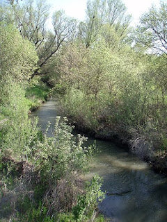 • 20 Putah Creek.
 • 03 Wild radish - Raphanus raphanistrum.
• More photos: BRT photos from South Fork Putah Creek Preserve.
Most of the South Fork Putah Creek Preserve is an open grassland that won't be very interesting until a lot more habitat restoration is completed. The Outer Loop and Inner Loop Trails have no shade and are mostly straight, flat, boring hiking between two barbed wire fences.
For more information:
• Putah Creek Watershed Directory - Recreation & Conservation. Websites for the Putah Creek Valley. (Sort alphabetically. 1&2=kayaking-rafting-canoeing-paddlesports, 3=conservation-environment, 4=fishing, 5=camping-hiking, 6=local-websites)
• Map & driving directions - South Fork Putah Creek Preserve - MapQuest.
• Researchers Determine Genetic Origin Of California Wild Radish - sciencedaily 19july2006.
• Flow Data for Putah Creek near Winters CA - USGS.
• Putah Creek Council.
• Hiking & Camping Trip Reports - BRT Insights.
• Olympus Stylus 720SW camera. Photos edited with IrfanView software.
IceRocket Tags: hiking, Sacramento Valley, Putah Creek, Yolo County, California.
Tags: wildflowers, photography, landscape photography.
Map of South Fork Putah Creek Preserve & nearby& landmarks.
• Instructions for online interactive topographic maps & road maps.• Click on Map button for road map, Topo button for topographic map.
• Full-Screen Map - South Fork Putah Creek Preserve & surroundings.
Wild radishes as well as a few types of microflora were blooming.
DoubleClick on photos to see larger images. Use back button to return.


• More photos: BRT photos from South Fork Putah Creek Preserve.
Most of the South Fork Putah Creek Preserve is an open grassland that won't be very interesting until a lot more habitat restoration is completed. The Outer Loop and Inner Loop Trails have no shade and are mostly straight, flat, boring hiking between two barbed wire fences.
Nearby hiking, biking & jogging opportunities.
West of Co Rd 104 the dirt roads that parallel Putah Creek on the north & the south both appear to be open for hiking & biking. I saw some joggers going on a trail that goes along the treeline even closer to the north side of the creek. The north side Levee Rd connects back to Davis via Drummond Ln and via Old Davis Rd.For more information:
• Putah Creek Watershed Directory - Recreation & Conservation. Websites for the Putah Creek Valley. (Sort alphabetically. 1&2=kayaking-rafting-canoeing-paddlesports, 3=conservation-environment, 4=fishing, 5=camping-hiking, 6=local-websites)
• Map & driving directions - South Fork Putah Creek Preserve - MapQuest.
• Researchers Determine Genetic Origin Of California Wild Radish - sciencedaily 19july2006.
• Flow Data for Putah Creek near Winters CA - USGS.
• Putah Creek Council.
• Hiking & Camping Trip Reports - BRT Insights.
• Olympus Stylus 720SW camera. Photos edited with IrfanView software.
IceRocket Tags: hiking, Sacramento Valley, Putah Creek, Yolo County, California.
Tags: wildflowers, photography, landscape photography.
Labels: hiking


