Monday, January 23, 2006
Wilderness Run, Cache Creek, Kayaking Jan 22, 2006.
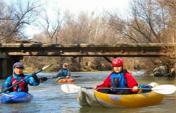
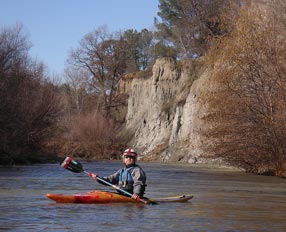
Jim, Masaaki, Yuriko and I drove to put-in for the Cache Creek Wilderness Run hoping that there would be enough flow to get us down the first part of the run on the NF Cache Creek (Lake County & Yolo County, California, United States). When we got there we found a throng of rafters loading up their 12 big boats and enough flow for us all!! The release from Indian Valley Reservoir was reported as only 100 cfs, but the flow had to be at least 200-300 cfs. After dodging a zillion strainers on the North Fork we got to the main part of Cache Creek with a very rambunctious 3000 cfs. There we dodged another zillion strainers, but at least there was a wider path down the middle of the river and more room to avoid them.


(photos by JimH)
Jim has posted additional pictures from our trip on his account at Flickr.
Wildlife
The highlights of the day were definitely the wild life, and a lot of it was not us. There was the little incident immediately after put-in, but that boat got unwrapped very quickly. Then there was the sticky ledge hole hiding in the middle of the wave train. Well, one of us missed it on the right and one missed it on the left. Two boaters went into the hole and two swimmers came out - amazing. There were a few other out-of-boat experiences throughout the day, especially the last one just before take-out. Swimming to take-out is not ideal, but at least nobody swam past takeout. Amazingly no gear was lost in any of our carnage. That metal thermos almost escaped, but it was recaptured when it foolishly eddied out.
Oh yea, the other wild life. Well, we saw more than a dozen bald eagles. Some were hanging out in trees overlooking the river, while others were soaring with the greatest of ease. Lots more big birds were soaring off in the distance, too far away for positive identification. We also saw a coyote, some deer, lots of merganzers, a few Great Blue Herons, and a few hawks. Its amazing how puny the hawks look when there are so many eagles around.
Big Water
Overall it was a glorious warm sunny day with crystal clear air. We had nice lively class 2 and 3 whitewater with class 4 strainers. At this flow its a "big water" experience with some great big wave trains and some really interesting hydraulics on the eddy lines. There were few if any playspots at this flow, but with long miles and short daylight we weren't really looking for playspots anyway. It was unusual to see so many rafters, but we only saw two of them again as we went down river. Just a typical winter run with the river almost completely to ourselves. A nice dinner at the Mexican restaurant in Winters on the way home finished off a spectacular day. The power of the river has recharged my psychic batteries.
More about:
• Additional trip report from Masa.
• Whitewater kayaking trip reports.
(keywords: whitewater river kayaking, kayak, kayaks, kayakers, rafting, raft, rafts, rafters, Cache Creek, Capay Valley, Yolo County, California, USA)
Tags: kayaking, whitewater, rivers, paddling.
Labels: trip
Comments:
<< Home
My son, Oliver, has expressed interest in taking our 12 foot raft down this run next weekend if the flows in the North Fork Cache Creek hold up, and it seems to be. We saw 12 rafts on the river Sunday. There was plenty of water in the north fork (3.3 ft and 100 cfs) and 3300 cfs in Cache Creek. We were on the river only 4.5 hours with several breaks. We didn't have to paddle much and had energy left at the end of the day. We had an interesting day. It was warm and sunny. BruceT, Masa-akiO, YurikoO, and I put-on at about 1030 and took out at highway 16 at 1515. We saw 18 bald eagles, 2 coyotes, 4 deer, lots of red tailed hawks, spotted sandpipers, kingfishers, and dozens of ducks, both mallards and mergansers. The manzanita was in full bloom. The car we left at highway 16, Masa-aki's, had a nearly flat tire when we got there. The lug wrench had a crack in it so we couldn't change the tire. I tried to hitch a ride back to the put-in, but couldn't get a ride, so we limped back to the put-in on the nearly flat tire. There I pumped it up with a pump I keep in my car and gave Masa-aki a can-of-air to use in case the tire went flat again before he got home. We noticed restrooms on river right about 2/3 the way down the run, and saw new restrooms on highway 16 and 20 as well. There is some information on these trail heads as well as links to maps and streamflow information at: http://www.ca.blm.gov/ukiah/cachecreek.html
The trailhead on Highway 16 1 mile south of highway 20 is Cowboy Camp. The Judge Davis Trailhead is on highway 20 at milemarker 46.07.
Although there is no mention of the Restrooms (campground?) on river right, the maps lead me to believe they are on Buck Island, and can be accessed via Fiske Creek and Langs Peak Roads from the low water bridge in the summer or in the winter by going north from Berryessa Reservoir on Berryessa-Knoxville road, Morgan Valley Road, and county road 40. I just may take a day to explore this route to see if the road is passable.
JimH
Post a Comment
The trailhead on Highway 16 1 mile south of highway 20 is Cowboy Camp. The Judge Davis Trailhead is on highway 20 at milemarker 46.07.
Although there is no mention of the Restrooms (campground?) on river right, the maps lead me to believe they are on Buck Island, and can be accessed via Fiske Creek and Langs Peak Roads from the low water bridge in the summer or in the winter by going north from Berryessa Reservoir on Berryessa-Knoxville road, Morgan Valley Road, and county road 40. I just may take a day to explore this route to see if the road is passable.
JimH
<< Home


