Wednesday, March 21, 2012
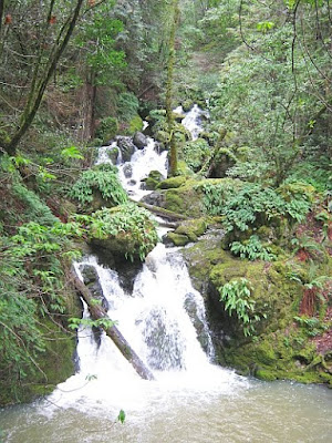
Cataract Falls hiking trail on Mount Tamalpais, Marin County, California
Waterfalls and redwood forest make a great place for hiking !!
JimH & I drove through Fairfax, CA and took the scenic Bolinas Fairfax Road to the trailhead at Alpine Lake Reservoir.Cataract Falls Trail - Road map, topographic map, satellite map and pdf map.
• PDF map: Watershed Visitor Maps - Marin Municipal Water District.• Map book: California Maps - Atlas & Gazetteer by Delorme, 2008.
• Online map user instructions. Click and drag to reposition this interactive map.
• The tool on the left zooms in and out. Point on the red markers to see the names.
• Map=roads. Satellite=satellite map. Terrain=3D shaded topo map. Topo=topographic map.
• Full-Screen online map - Cataract Falls Trail.
Coordinates - landmark (marker).
N 37.93651 W 122.63785 - Trailhead elevation 680 ft (A)
N 37.92362 W 122.62738 - Rio Dell elevation 1660 ft (B)
Cataract Falls trail to Laurel Dell is delightful on the first sunny day after a rainstorm !!
The Cataract Falls Trail starts along the placid shores of Alpine Lake Reservoir then rises steeply for 1.6 mi to Laurel Dell on the north slope of Mount Tamalpais. After a bit of hiking we started to hear the sounds of the waterfalls on Cataract Creek. There are multiple waterfalls and lots of whitewater in between them. The incredible sparkle and energy of the creek are with you the entire way up the trail to Laurel Dell.Doubleclick on the photos to see the large size image - use the back button to return.
The canyon has a lush, beautiful, second growth redwood forest with lots of interesting ferns, mosses and the occasional spring flower on the forest floor.
More photos: 2012-03-18 Cataract Falls, Marin County.
Going There and Coming Home
On this trip we had a rare opportunity to get both breakfast and dinner at Betty Lou's Bar & Grill in Vacaville, CA. Scrambled eggs, home fried potatoes and coffee fortified us for the hike. Then on the way home we stopped there again for corned beef & cabbage, some dark beer and a Harry Potter movie.Additional information:
• Waterfall Hiking in California - websites - BRT Insights.
• Hiking Trails in California - Davis Wiki.
• Hiking, Biking & Camping Trip Reports & Photos - BRT Insights.
• Digital Camera: Canon PowerShot A490. Photos edited with IrfanView and GIMP software. Video edited with Windows Movie Maker and YouTube tools.
Tags: hiking, trail, Cataract Falls, Mount Tamalpais, Marin County, California, waterfalls.


