Saturday, February 16, 2013
Black Dragon Brewery, Woodland, CA (Yolo County)
On our way back from biking at Fremont Weir Wildlife Area JimH & I stopped at Black Dragon Brewery for lunch. Drakemic Imperial Stout and the Wanderer's Lunch were both excellent!
Black Dragon Brewery Map.
• Map book: California Maps - Atlas & Gazetteer by Delorme, 2008.• Online map user instructions. Click and drag to reposition this interactive map.
• The tool on the left zooms in and out. Point on the red markers to see the names.
• Map=roads. Satellite=satellite map. Terrain=3D shaded topo map. Topo=topographic map.
• Full-Screen online driving map - Black Dragon Brewery.
Geographic Coordinates - Landmarks (Marker)
N 38.67693 W 121.79237 - Black Dragon Brewery (A)
N 38.67479 W 121.78207 - Reiff's Antique Gas Station Museum (B)
Click on the photos to see the larger view. Use the back button to return.
2940 - Black Dragon Brewery
2944 - Beers on tap.
2951 - Black Dragon Brewery
2956 - Lunch.
More photos:
JimH photo - Black Dragon Brewery
BRT photos - Black Dragon Brewery
On our way home we took a short detour to cruise past local landmark Reiff's Antique Gas Station Museum.
Tags: Black Dragon Brewery, Woodland CA, Yolo County, California.
Labels: restaurant
Friday, February 15, 2013
Fremont Weir Wildlife Area - mountain biking in Sutter and Yolo Counties, California
JimH & I drove out to Fremont Weir Wildlife Area (6 miles north-east of Woodland, CA) to explore by mountain biking. Sacramento River was at a level of 17.5 feet which is 16 feet below the top of the weir.
Fremont Weir Wildlife Area Maps.
• Download map: Fremont Weir Wildlife Area Map PDF. Driving Map PDF.• Map book: California Maps - Atlas & Gazetteer by Delorme, 2008.
• Online map user instructions. Click and drag to reposition this interactive map.
• The tool on the left zooms in and out. Point on the red markers to see the names.
• Map=roads. Satellite=satellite map. Terrain=3D shaded topo map. Topo=topographic map.
• Full-Screen online driving map - Fremont Weir Wildlife Area.
Geographic Coordinates - Landmarks (Marker)
N 38.75897 W 121.66785 - trailhead and parking (A)
N 38.75906 W 121.66546 - Fremont Weir west end (B)
N 38.76470 W 121.63552 - Fremont Weir east end (C)
Click on the photos to see the larger view. Use the back button to return.
2910 - Fremont Weir
Biking at Fremont Weir Wildlife Area
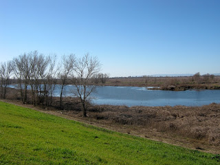
The road along the west side of the wildlife area is private. We made a cross-country loop through the north-west corner of the wildlife area. When some lakes blocked our progress we went north to the weir and proceeded east on the 2-track dirt road on the north side of the weir. Biking along the weir provided easy biking, great views of the landscape to the south and occasional views of the Sacramento River to the north. We stopped to eat some homemade cranberry walnut granola bars and have some of my PowerT Energy Drink recipe.Once we got to the east end of the weir we got on the dirt road on the top of the levee. We explored about a mile to the north on Rd 107. This part of the levee road provides scenic views of the river on the left and farmland on the right. There are many more miles of scenic levee road that we can explore maybe next time. Then we went south on County Rd 16 on top of the levee to see the east side of the wildlife area. Cross-country travel into the center of the wildlife area was blocked by a long narrow lake paralleling the levee, but the scenery from the top of the levee was fine. On the way back north we took a path down at lake level. Then we retraced our path along the weir to get back to Jim's truck at the entrance.
Despite the small size of the wildlife area we saw quite a bit of wildlife. We saw 3 different groups of deer, lots of small birds, a few raptors, a flock of quail, a great blue heron and some small ducks. The first few wildflowers of spring were blooming.
2919 - Sacramento River
2932 - Rd 107 Levee Road
2937 - view from County Rd 16
More photos:
• JimH photos at Fremont Weir Wildlife Area
• BRT photos at Fremont Weir Wildlife Area
Slideshow:
Coming Home
On the way home we stopped for an excellent lunch at Black Dragon Brewery in Woodland, CA. See the BlackDragon Brewery trip report.Additional information:
• Hiking Trails in California - Davis Wiki.
• Hiking, Biking & Camping Trip Reports & Photos - BRT Insights.
• Digital Camera: Canon PowerShot A490. Photos edited with IrfanView and Windows Live Movie Maker.
Tags: mountain biking, trail, Fremont Weir Wildlife Area, Sutter County, Yolo County, California.
Labels: biking, map, wildflowers


