Sunday, April 11, 2010
Stebbins Cold Canyon Reserve hiking & wildflowers, Solano County, California USA.
Blue Ridge Loop Trail - wildflowers & scenic views.
RichardM, LynneN & I hiked part of the Blue Ridge Loop Trail at Stebbins Cold Canyon Reserve on 10april2010. We did a short steep hike from the trailhead on the west side of Cold Creek (elevation 280 ft) up to the top of Blue Ridge (elevation ~1200 ft) where we had lunch at a great overlook onto Lake Berryessa.Map of Stebbins Cold Canyon Reserve & Solano County.
• Instructions for online interactive topographic maps & road maps.• Click on Map button for road map, Topo button for topographic map.
• Full-Screen Map - Stebbins Cold Canyon Reserve in Solano County.
• Names of landmarks (A, B, etc.) - DoubleClick or point on the red markers.
N 38.50889 W 122.09733 - Cold Canyon Trailhead, elevation 280 ft (A)
N 38.50973 W 122.10409 - Lake Berryessa overlook, elevation ~1200 ft (B)
Cold Canyon GPS trail maps & photos.
• Stebbins Cold Canyon gps hiking & landscape photography - SierraHike 19feb2010.• Stebbins Cold Canyon gps hiking photos - SierraHike 07march2010.
• Cold Canyon Loop Trail gps hiking elevation profile - cswift2 07dec2007
Cold Canyon hiking trails map.
• Doubleclick map to see larger version - back button to return.Many different kinds of wildflowers were blooming on the steep trail up to the top of Blue Ridge.
DoubleClick on the photo to see a larger version - use the back button to return.
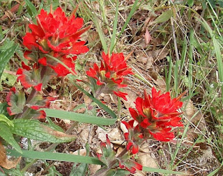
• Photo 90 - Indian Paintbrush. (Castilleja affinis ssp. affinis)
• Photo 101 - Overlook to Lake Berryessa. It was a very calm, peaceful spot to have lunch while watching many turkey vultures soaring serenely in the valley below us.
• Photo 125 - Bush Monkeyflower. (Mimulus aurantiacus)
Then Lynne & I did a quick hike along the east side of Cold Creek. Down at the bottom of the valley by the creek we found some different wildflowers that were not observed on the west side higher up on the flanks of Blue Ridge.
• Photo 145 - Cold Creek.
• More: BRT photos at Stebbins Cold Canyon Reserve.
My homemade sports drink recipe flavor of the day was Old Orchard Blueberry Pomegranate 100% all natural juice. Good hydration is critical for muscle performance for hikers and all other athletes. While hiking in search of wildflowers, scenery and photo opportunities it is too easy for me to forget to drink enough. The fruit flavor from the juice encourages me to drink. The sugar from the juice provides rapidly burned fuel for my muscles. The salt in the recipe stimulates my thirst and encourages me to drink even more!
For more information:
• Map to the Trailheads - Hiking in Solano County, California.
• Stebbins Cold Canyon Reserve hiking 25sept2011.
• Hiking at Stebbins Cold Canyon - UC Davis Natural Reserve System
• Cold Canyon Trails - YoloHiker
• Cold Canyon Loop 28X - Pete's Thousand Peaks
• Stebbins Cold Canyon - Berryessa Trails
• Ted's Outdoor World - Stebbins Cold Canyon Reserve
• California Maps - Atlas & Gazetteer by Delorme, 2008.
• California Hiking Trails - Statewide Information.
• Hiking in Solano County - Vacaville Wiki
• Putah Creek Recreation & Conservation Directory. (Sort alphabetically. Section 5 = camping & hiking)
• Hiking & Camping Trip Reports - BRT Insights.
• Olympus Stylus 720SW camera. Photos edited with IrfanView & PanoStitcher.
IceRocket Tags: hiking, Stebbins Cold Canyon Reserve, Solano County, California.
Tags: wildflowers, photography, landscape photography.
Labels: hiking
Comments:
<< Home
Nice shots on a wonderful hike! Have you hiked the Blue Ridge trail to the top for those magnificent vistas?
Thanks, we just did a short hike up to a rock spire with a good overlook on the dam & the lake. Hopefully next time I go there I will hike the rest of the Cold Canyon Loop Trail.
Post a Comment
<< Home


