Thursday, December 30, 2010
Fairy Falls Trail, Spenceville Wildlife Area hiking trip report - Nevada County, California USA.
(29dec2010) A sunny day immediately after a rainstorm is a great time to go hiking. And even more so if your hiking destination is a waterfall. We debated going to another more famous falls along the coast, but I think we made the right choice.
Double-click on the photos to see the large version, then use the back button to return.
 • Fairy Falls Trail at Spenceville Wildlife Area.
 • Upper Fairy Falls at Spenceville Wildlife Area.
• More BRT photos: Spenceville Wildlife Area hiking photos 2010-12-29.
• Fairy Falls, Spenceville Wildlife Area photos with map locations - brthomas.
• Olympus Stylus 720SW camera. Photos edited with IrfanView software.
• Fairy Falls (a.k.a. Shingle Falls) photos - JimH.
• Fairy Falls (a.k.a. Shingle Falls) photos with map locations - EveryTrail - ElRemaro
• Pentax Optio W10 waterproof camera.
• Mapping Methods and GPS Equipment for Travel Photography.
Whoever named this place Fairy Falls must have been there in the summertime, perhaps when minimal creek flows might provide delicate little trickling waterfalls. After a big winter rainstorm there is nothing delicate about these roaring mighty waterfalls! The USGS gage height on Dry Creek was at 11 feet on the day when we hiked there.
• BRT video taken with Olympus Stylus 850SW waterproof camera.
Returning from the falls we climbed up the hill and hiked back on the Upper Loop Trail. From there we got some good views of Sutter Buttes. Then on the drive home we took a scenic detour to get a close-up look at the south side of Sutter Buttes.
• Use the tool on the left to zoom in and out. Point on the red markers to see their names.
• Map button = road map. Terrain = 3D shaded topo map. Topo = topographic map.
• Full-Screen Road and Topographic Map: Fairy Falls and Spenceville Wildlife Area.
N 39.11395 W 121.27104- Trailhead (A)
N 39.11498 W 121.24293 - Fairy Falls (B)
N 39.02638 W 121.43611 - USGS Dry Creek flow gauge (C)
N 39.20572 W 121.82027 - Sutter Buttes (D)
For more information:
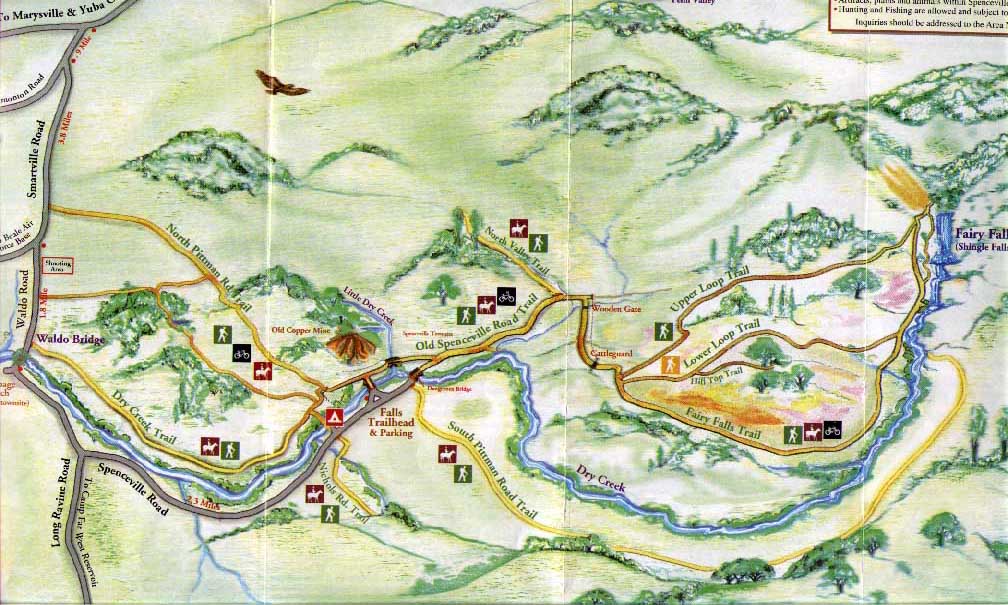
• Spenceville Wildlife Area Hiking Trails Map - Sierra Outdoor Recreation.
• Fairy Falls - Yuba-Sutter Wiki.
• Friends of Spenceville Wildlife Area.
• Spenceville Wildlife Area - CA Dept Fish and Game.
• Hiking, Camping and Biking Trip Reports - BRT Insights.
• California Hiking Trails - Statewide Information.
• California Maps - Atlas & Gazetteer by Delorme, 2008.
IceRocket Tags: hiking, Fairy Falls, Spenceville Wildlife Area, Nevada County, California.
Tags: waterfalls, photography, landscape photography.
Spenceville Wildlife Area hiking trails.
We hiked out to the falls on the Fairy Falls Trail. See the trails map from Friends of Spenceville. (Use the back button to return.) Fall, winter & spring are great times for hiking at Spenceville Wildlife Area in the Sacramento Valley. The oak woodland habitat is excellent for hiking. Elevation at the trailhead is 280 feet. On a cool day the hiking trails that are mostly or entirely exposed to the sun are delightful, but I can imagine that it would be brutal to hike there on a hot summer day. I used grape juice & black tea in my homemade energy-sports drink recipe for hydration while hiking. Even with a favorite tasty mixture to drink I unfortunately fell back into my bad old habit of not drinking enough during the hike.Double-click on the photos to see the large version, then use the back button to return.

Fairy Falls (a.k.a. Shingle Falls, Dry Creek Falls, Beale Falls).
Our main objective for the day was to hike to Fairy Falls on Dry Creek. The headwaters for Dry Creek are in eastern Nevada County on the north-west side of Sugar Loaf Mountain. Flowing west out of the Sierra foothills, the Dry Creek watershed is north of the Bear River and south of the Yuba River. The USGS flow gauge on Dry Creek is more than 10 miles downstream from Fairy Falls. Checking this flow level before you hike is a good way to predict the kind of flow you'll see at the falls. Dry Creek joins the Bear River just upstream from the Bear River confluence with the Feather River south-west of Wheatland, CA. The last stretch of road on the drive to the trailhead is on Spenceville Road which runs along Dry Creek. The flow you see there is another way to judge the kind of flow you'll see when you hike upstream to Fairy Falls.
• More BRT photos: Spenceville Wildlife Area hiking photos 2010-12-29.
• Fairy Falls, Spenceville Wildlife Area photos with map locations - brthomas.
• Olympus Stylus 720SW camera. Photos edited with IrfanView software.
• Fairy Falls (a.k.a. Shingle Falls) photos - JimH.
• Fairy Falls (a.k.a. Shingle Falls) photos with map locations - EveryTrail - ElRemaro
• Pentax Optio W10 waterproof camera.
• Mapping Methods and GPS Equipment for Travel Photography.
Whoever named this place Fairy Falls must have been there in the summertime, perhaps when minimal creek flows might provide delicate little trickling waterfalls. After a big winter rainstorm there is nothing delicate about these roaring mighty waterfalls! The USGS gage height on Dry Creek was at 11 feet on the day when we hiked there.
• BRT video taken with Olympus Stylus 850SW waterproof camera.
Returning from the falls we climbed up the hill and hiked back on the Upper Loop Trail. From there we got some good views of Sutter Buttes. Then on the drive home we took a scenic detour to get a close-up look at the south side of Sutter Buttes.
Road Map and Topographic Map - Spenceville Wildlife Area.
• Map user FAQ. The map is interactive. Click and drag to reposition map.• Use the tool on the left to zoom in and out. Point on the red markers to see their names.
• Map button = road map. Terrain = 3D shaded topo map. Topo = topographic map.
• Full-Screen Road and Topographic Map: Fairy Falls and Spenceville Wildlife Area.
N 39.11395 W 121.27104- Trailhead (A)
N 39.11498 W 121.24293 - Fairy Falls (B)
N 39.02638 W 121.43611 - USGS Dry Creek flow gauge (C)
N 39.20572 W 121.82027 - Sutter Buttes (D)
For more information:
• Spenceville Wildlife Area Hiking Trails Map - Sierra Outdoor Recreation.
• Fairy Falls - Yuba-Sutter Wiki.
• Friends of Spenceville Wildlife Area.
• Spenceville Wildlife Area - CA Dept Fish and Game.
• Hiking, Camping and Biking Trip Reports - BRT Insights.
• California Hiking Trails - Statewide Information.
• California Maps - Atlas & Gazetteer by Delorme, 2008.
IceRocket Tags: hiking, Fairy Falls, Spenceville Wildlife Area, Nevada County, California.
Tags: waterfalls, photography, landscape photography.
Comments:
<< Home
I appreciate all the interesting links you found. I might consider taking the south Pittman Road next time to get a different angle for photographing the falls.

Thanks, I'm always eager to link to the best online resource websites.
I agree. The South Pittman Road Trail looks like a good way to get a different perspective on the falls.
I agree. The South Pittman Road Trail looks like a good way to get a different perspective on the falls.
Amazing water flow and nice write up of your experience. I appreciate the link to check the flow before driving all the way up there!
Post a Comment
<< Home
![]()


